Prairie of Knobs
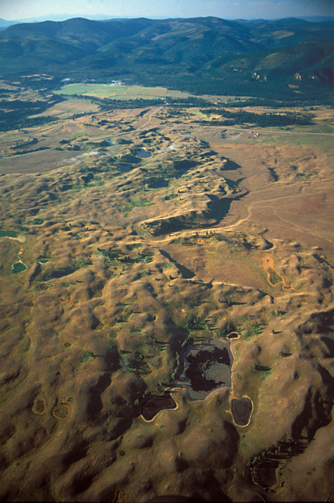
The Blackfoot River is to the right of the scene above; the town of Ovando, Montana, is below the bottom of the photo. See Clark’s Maps.
On 6 July 1806, Clark and his contingent were, with Sacagawea‘s help, threading their way through a maze of Indian roads in the Big Hole Valley, en route back to Fortunate Camp. Meanwhile, 120 miles to the north, Lewis’s eleven-man party had broken camp at the mouth of a Blackfoot River tributary they named Seaman’s Creek, after Lewis’s dog, and headed on up the river along the “road” that Indians living in the Rocky Mountains called the Cokahlahrishkit—the Road to the Buffalo.
The road led Lewis and his men to the north of an “extensive high prarie rendered very uneven by a vast number of little hillucks and sinkholes.” Lewis noted: “These plains I called the prarie of the knobs from a number of knobs being irregularly scattered through it.” Those “knobs” are mounds of debris deposited by piedmont glaciers during the last ice age, which ended about ten thousand years ago. Interspersed among them are numerous ponds or glacial tarns of various sizes and shapes, many long since reduced to moist, grassy little depressions.
Indian Signs
“level beautifull plain”
To see labels, point to the photo.
© 2003 Airphoto, Jim Wark. All rights reserved.
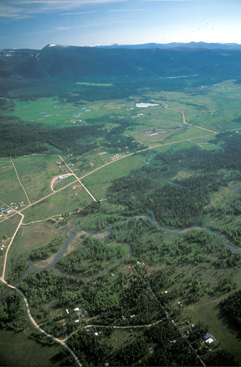
Lewis’s detachment pitched camp on 6 July on the bank of Beaver Creek, two miles west of present Lincoln, Montana. Lincoln began as a mining town and stagecoach station in 1865, after the discovery of gold in nearby Abe Lincoln Gulch.
It was in Lincoln that the 20th-century outlaw, the Unabomber, Ted Kazinski, survived in virtual isolation while nursing his deep hatred of technological progress, and sowing terror nationwide for nearly eighteen years, until his capture there in 1996.
The warning that their Nez Perce guides had given them on the morning of the fourth was always on their minds. Lewis and his nine men were becoming more aware by the hour that they were in hostile territory. At the western border of this “beautifull plain”—a short distance out of the photo, at left—they counted the remains of 32 Indian lodges. They were dogging the tracks of what they surmised to be a war-party of “the Minnetares of Fort de prarie,” and the tracks were looking fresher by the hour. Nevertheless, they proceeded on, prepared for the worst. “We expect to meet with the Minnetares and are therefore much on our guard both day and night.”
Even though they knew their guns would alert any potential foe within earshot, the hunters worked hard and bagged five deer and a beaver. The party had plenty to eat that night, and was well provisioned for the next few days. There was “much sign of beaver in this extensive bottom,” and they’re still fairly plentiful today.
Heading east early the next morning they saw some signs of bison in the valley not far from their camp, which showed that those herds sometimes penetrated the mountains at least a few miles. Sometime that morning Reubin Field wounded a moose near camp. Lewis remarked, “my dog much worried.”
Experience the Lewis and Clark Trail
The Lewis and Clark Trail Experience—our sister site at lewisandclark.travel—connects the world to people and places on the Lewis and Clark Trail.
Discover More
- The Lewis and Clark Expedition: Day by Day by Gary E. Moulton (University of Nebraska Press, 2018). The story in prose, 14 May 1804–23 September 1806.
- The Lewis and Clark Journals: An American Epic of Discovery (abridged) by Gary E. Moulton (University of Nebraska Press, 2003). Selected journal excerpts, 14 May 1804–23 September 1806.
- The Lewis and Clark Journals. by Gary E. Moulton (University of Nebraska Press, 1983–2001). The complete story in 13 volumes.


