Figure 1
Clark’s Arrival at the Pacific Ocean
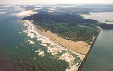
Cape Disappointment (view north by northwest)
To see labels, point to the image.
© 2000 Airphoto—Jim Wark
Gass’s Mountains of Waves
The morning of 16 November 1805, was clear and beautiful but the southwest wind whipped up the water. “We could see the waves, like small mountains, rolling out in the ocean,” wrote Patrick Gass, “and pretty bad in the bay.” Those waves marked the world-famed Columbia Bar, the sandy shoal that practically blocks the broad mouth of the river, where breakers sometimes reach 40 feet in height. The hunters bagged some “pore” (lean, that is) deer and a few waterfowl.
In keeping with common practice among explorers in those days, the two captains and several of the men chiseled their names and the date, “& by Land &c. &c.,” in the soft stone of the cliffs. Evidently, their marks have never been found.
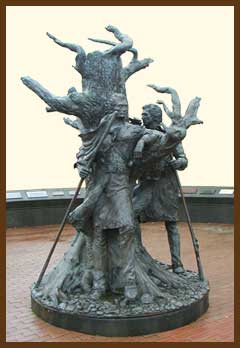
Clark’s Arrival at the Pacific
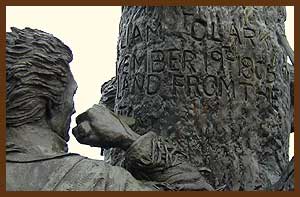
This sculpture by Stanley Wanlass, situated in the city of Long Beach, Washington, commemorates that moment. Although Lewis was not with Clark on 19 November 1805, the artist places him there, as if present in spirit, to symbolize their mutual triumph.
On 18 November 1805, Clark and his ten-man party proceeded southwest along the shore of Baker Bay, at upper right in Fig. 1, passing a popular trading-ship anchorage where they carved their names on trees. Somewhere in that vicinity, Reubin Field killed the first California condor they had seen, which they identified, Sergeant Ordway recorded, as “a verry large turkey buzzard which had white under its wings, and was nine feet from the points of the wings, and 3 feet 10 Inches in length.” They then clambered up onto the narrow peninsula at far right; the tip of Cape Disappointment is beyond the right edge of the photo. The lighthouse which still warns mariners away from the cape was built in 1853-56. Its light can be seen 20 miles out to sea.
Turning northwest again, they climbed McKenzie Head, which was then “a high Seperate bald hill Covered with long corse grass & Seperated from the hight of Country by a Slashey bottom.” Today it’s the dark little bump just above and to right of photo center, surrounded by land that built up during the twentieth century behind the North Jetty, which is that long, dark line of rocks extending up diagonally from the bottom of the picture. Clark was pleased that his men appeared “much Satisfied with their trip beholding with estonishment the high waves dashing against the rocks & this emence ocean.” That awesome view of the sea was the focal point of their ultimate triumph.
The point of land projecting through the surf into the ocean above photo center is North Head—the windiest place on the West Coast, with a record blow of 120 mph. A lighthouse was completed in 1898 as a supplement to the Capt Disappointment light, to guide mariners approaching from the north. Its revolving beam, situated 190 feet above sea level, can be seen from 17 miles away.
Private Whitehouse thought his captains had named Cape Disappointment “on account of not finding Vessells there,” but it had received the name years earlier. For generations, sailors had sought the entrance to the “Great River of the West.” In 1788 a British trader named John Meares thought he had found it, but, unable to cross the sandy bar, he concluded that it was not the estuary of a river but just a bay. He named it Deception, and the cape on its north side, Disappointment. Four years later Robert Gray, a trader from Boston, found the river’s narrow channel and sailed his ship Columbia Rediviva across the bar, discovering that this body of water was indeed a river, which he named after his ship.
Exploring Long Beach
Clark awakened early on 19 November 1805 “from under a wet blanket caused by a Shower of rain which fell in the latter part of the last night.” He and his party “proceeded on thro emencely bad thickets & hills.” From the top of the hill today called North Head, he noticed a “Point of high land” twenty miles distant, north of the photograph. “This point,” he journaled, “I have taken the Liberty of Calling after my particular friend Lewis.” Lewis’s Point may have been today’s Leadbetter Point, at the northern end of Long Beach Peninsula. On his 1793 map, George Vancouver had drawn a point in this vicinity that may have represented this tip of land, but his rendering was more conspicuous than any landmark in the area today.
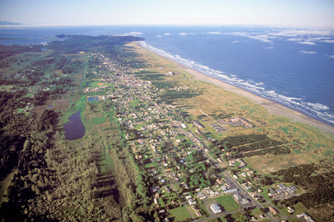
Clark’s party continued north along the beach for four miles, to the vicinity of today’s Long Beach, Washington. Here Clark memorialized their first visit to the Pacific Ocean by marking his name and the date on a small pine tree. Once again proving his keen geographical intuition, he led his contingent back to the hill, overland a few miles through dense forest to Baker Bay, and back to camp.
The following day Sacagawea relinquished her belt of blue beads—”Chief beads,” the prime legal tender on the Northwest Coast—so the captains could buy a robe made of two sea otter skins as absolute proof they had reached the Pacific Ocean. Clark wrote, “The fur of them [was] more butifull than any fur I had ever Seen.”
The Columbia’s Other Side
The men began to long for a more placid environment, some suggesting that they move back upriver to the Cascades of the Columbia to camp for the winter. Indeed, it became clearer every day that they would have to move somewhere. The Chinook Indians demanded higher prices for food and furs than the Corps was capable of paying and besides, they wanted payment in blue beads—”chief beads”—which the explorers were low on. Also, it was reported that elk, which they needed for clothing as well as food, were much more plentiful on the south side of the river.
On the 24 November 1805 every member of the party, including York and Sacagawea (but not Charbonneau, for some unknown reason), was asked to vote on the matter. A large majority favored crossing to the south side and examining their prospects there.
Their canoes not being equal to the demands of the four-mile trip directly across the open water of the estuary, the Corps set out upriver on the 26 November 1805, stayed the night near their camp of the previous 7 November 1805, and made their way among the sheltering islands to the south shore.
Cape Disappointment is a High Potential Historic Site along the Lewis and Clark National Historic Trail managed by the U.S. National Park Service. The site is a Washington State Park.—ed.
Experience the Lewis and Clark Trail
The Lewis and Clark Trail Experience—our sister site at lewisandclark.travel—connects the world to people and places on the Lewis and Clark Trail.
Discover More
- The Lewis and Clark Expedition: Day by Day by Gary E. Moulton (University of Nebraska Press, 2018). The story in prose, 14 May 1804–23 September 1806.
- The Lewis and Clark Journals: An American Epic of Discovery (abridged) by Gary E. Moulton (University of Nebraska Press, 2003). Selected journal excerpts, 14 May 1804–23 September 1806.
- The Lewis and Clark Journals. by Gary E. Moulton (University of Nebraska Press, 1983–2001). The complete story in 13 volumes.


