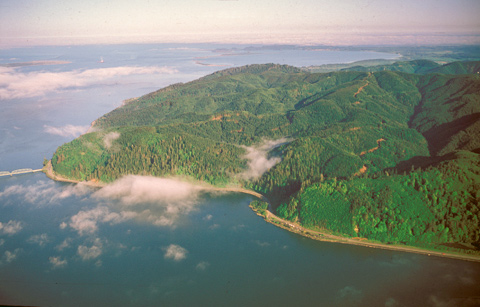
It was “the most disagreeable time I have experienced,” Clark grumbled on 15 November 1805. “Confined on a tempiest [tempestuous?] Coast wet, where I can neither get out to hunt, return to a better Situation, or proceed on.” For six days, gigantic swells had held the Corps down in the small clearing near the left end of the large cloud at left center of the picture (the bridge spans the estuary between Point Ellice[1]Point Ellice was named for the British merchant and politician Edward Ellice (1783-1863), nicknamed “The Bear,” who entered the Canadian fur trade in 1804, and merged the North West and … Continue reading in Washington, and Oregon at the town of Astoria). Clark had yet to see the ocean as pacific as it appears in the photo. The day before, Lewis had set out down the shore with four men “to examine if any white men were below.”
In the meantime, when the eleven-day rain spell abated about 3 p.m. on the 15th, the company hastily loaded the canoes and rounded the promontory to which Clark had given three names, all reflecting its treacherousness—”blustering point,” “Stormey point,” and “Point Distress.” On a sandy beach beyond the bridge in the picture, near an abandoned Chinook Indian village at the east end of Haleys Bay—today’s Baker Bay—the ocean’s swells drove them back to the marshy bottom, where they stayed for ten more days.
“We are now at the end of our voyage,” wrote Sergeant Gass, “which has been completely accomplished according to the intention of the expedition, the object of which was to discover a passage by the way of the Missouri and Columbia rivers to the Pacific ocean; notwithstanding the difficulties, privations and dangers, which we had to encounter, endure and surmount.”
On 24 November 1805, the sky cleared, and that evening the captains deliberated on what to do next. They polled the party, including York and Sacagawea. The decision was “to Cross the river and examine the opposite side,” where they could hunt elk, refine sea salt, and watch for ships from which they might refresh their depleted supply of Indian trade goods.
From Discovering Lewis & Clark from the Air
Photography by Jim Wark
Text by Joseph Mussulman
Reproduced by permission of Mountain Press
Notes
| ↑1 | Point Ellice was named for the British merchant and politician Edward Ellice (1783-1863), nicknamed “The Bear,” who entered the Canadian fur trade in 1804, and merged the North West and Hudson’s Bay fur companies in 1821. The Canadian Encyclopedia, http://www.thecanadianencyclopedia.com/index.cfmPgNm=TCE&Params=A1ARTA0002580 (Retrieved 29 August 2008). |
|---|
Experience the Lewis and Clark Trail
The Lewis and Clark Trail Experience—our sister site at lewisandclark.travel—connects the world to people and places on the Lewis and Clark Trail.
Discover More
- The Lewis and Clark Expedition: Day by Day by Gary E. Moulton (University of Nebraska Press, 2018). The story in prose, 14 May 1804–23 September 1806.
- The Lewis and Clark Journals: An American Epic of Discovery (abridged) by Gary E. Moulton (University of Nebraska Press, 2003). Selected journal excerpts, 14 May 1804–23 September 1806.
- The Lewis and Clark Journals. by Gary E. Moulton (University of Nebraska Press, 1983–2001). The complete story in 13 volumes.


