Map of the Falls of the Missouri and Portage Route[1]Photographed by Cary Horton; image 2002-NS 27638.
To see text and labels, point to the map.
Missouri Historical Society.
Mapping the Falls of the Missouri
Clark drew his sketch map of the falls of the Missouri, including the expedition’s portage-route around them, during the third week in June 1805. It is in the codex, or manuscript book, known as Voorhis No. 1, which contains Clark’s daily journals for the period 7 April 1805 through 13 July 1805. Voorhis No. 1 is one of three red-bound journals of Clark’s that Reuben Thwaites found at the New York home of Julia Clark Voorhis in 1903. Mrs. Voorhis had obtained them from the estate of her father, William Clark‘s fourth child, George Rogers Hancock Clark.[2]Paul Russell Cutright, A History of the Lewis and Clark Journals (Norman: University of Oklahoma Press, 1976), 117-120. The Voorhis Collection is now part of the Clark Family Collection in the William Clark Papers at the Missouri Historical Society Archives in St. Louis, Missouri.
The importance of this segment of the Missouri River in the history of the Lewis and Clark expedition is reflected in Clark’s journal entry for 5 July 1805, written at the upper portage camp: “I employ my Self drawing a Copy of the river to be left at this place for fear of Some accident in advance.”
An engraving based on Clark’s sketch was printed in Paul Allen’s edition of Nicholas Biddle‘s paraphrase of the expedition’s journals (1814).
John Evans’ Confusion
During the winter of 1803-1804 the captains gained much valuable information and advice from a Scotsman in St. Louis named James Mackay. In 1795 Mackay, the manager of the Spanish-controlled Missouri Fur Company’s operations on the lower Missouri River, sent John Thomas Evans on a mission to find the elusive Northwest Passage. Evans got no farther than the Knife River villages, but while there he acquired information from the Mandans and Hidatsas about the land that lay between their homeland and the Rocky Mountains.
The Indians, Evans reported, “have but a Confused Idea of the upper parts of the Missouri.”
Nevertheless after all the Information I could collect, it appears that the Missouri takes it source in abt. The 40th deg. North latitude from Whence it Runs to the North (between the chains of the Rocky Mountains) as far as the 49th deg. Latitude that thence running East it falls over the East chain of the Mountains in the great plains across which it runs to the East till it reaches the Maindaines . . . There is no other fall, in the whole Course of the Missouri, but where it falls over the Rocky Mountains, in the plains, as I have said before. This fall it is Said, is of an astonishing height, from the Situation of the Country and the Meanders of the River I suppose this fall to be 200 leagues West of the Mandaines.[3]A. P. Nasatir, ed., Before Lewis and Clark: Documents Illustrating the History of the Missouri 1785 -1804 (2 vols., Lincoln: University of Nebraska Press, 1990), 2:498.
No doubt Evans’ impression of Indian “confusion” was a result of communication problems across the language barriers between two cultures accustomed to different ways of measuring time, distance and direction; having different reasons for traveling through the same land; and using different modes of travel.[4]See James P. Ronda, “‘A Chart in his Way’: Indian Cartography and the Lewis and Clark Expedition.”Great Plains Quarterly, 4 (Winter 1984), 43-53. In view of that, it is no wonder that his conclusions spanned a wide spectrum of truth and probability. For example, the fortieth parallel runs near Provo, Utah, and Denver, Colorado, more than 300 statute miles south of the farthest source of the Missouri, which is a lake at 44° 33′ North Latitude.[5]Lewis ultimately left “Jefferson’s” river—today’s Beaverhead River—today’s at the forty-fifth parallel and turned westward. He did not know he was still 128 river … Continue reading
On the other hand, the river twice touches its northernmost point at about the forty-eighth parallel—downstream from Fort Benton, and again at Brockton in extreme northeastern Montana—which is only sixty-nine statute miles south of Evan’s forty-ninth. But his understanding that the landmark waterfall was downstream from the river’s northernmost point would lead to erroneous expectations, with commensurate frustrations to the traveler.
The Captain’s Confusion
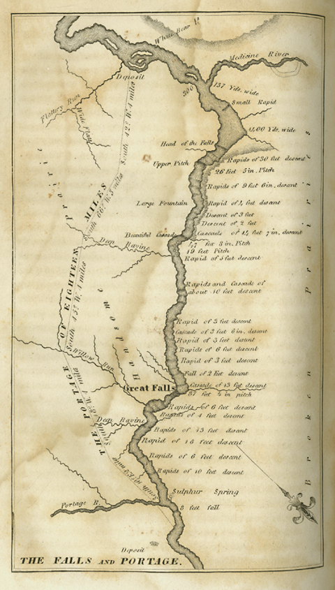
Clark’s map, engraved for the first edition of the journals
To see text and labels, point to the map.
Special Collections, Mansfield Library, The University of Montana, Missoula.[6]From Paul Allen, ed., History of the expedition under the command of Captains Lewis and Clark, to the sources of the Missouri, thence across the Rocky Mountains and down the river Columbia to the … Continue reading
The copy from which this image is reproduced was owned by Henry Villard (1835-1900). Villard was the principal financier of the Northern Pacific Railroad, completed in 1882, which paralleled much of Clark’s route through the Gallatin and Yellowstone valleys.
Evans was able to ask questions, to translate the Indians’ answers, and factor in his own experience, in ways that would enable him to estimate the distance from the Knife River villages to the falls with reasonable accuracy. Although the league is historically a variable unit of measurement, in Clark’s day it was equal to three statute miles.[7]Noah Webster, A Compendious Dictionary of the English Language (1806; reprint, New York: Crown Publishers, 1970). Therefore, by Evans’ estimate the waterfall would be 600 river miles west of the Mandan villages. It is actually 733 river miles away today, and given its geological constraints within that part of the Missouri River, the distance could not have been much different in 1805. One can imagine the apprehensions in the captains’ minds as the miles added up. Without yet having come upon the falls, the Corps faced a crucial decision at Maria’s River—at mile 876 according to Clark’s “courses and distances.” When they reached rapids (now known as the Big Eddy), six river miles below the falls, Clark’s estimates added up to 930.5 miles.
In their deliberations at the mouth of the Marias over which branch to ascend, Lewis recalled (9 June 1805) that the Indians at Fort Mandan had informed them that “the falls lay a little to the South of sunset from them,” and that “the falls are below the rocky mountains and near the Nothern termineation of one range of those mountains.” His own observations seemed to corroborate the Indian information: A range of mountains, “which appear to terminate S. W. from this place and on this side of the unbroken chain of the Rocky Mountains gives us hope that this part of their information is also correct.” (He could have been seeing the overlapping island ranges now called the Highwood, Big Belt, and Little Belt mountains.) Then he added, with an uncharacteristic hint of pessimism—or perhaps just cynicism over the efficiency of cross-cultural communication—”there is sufficient distance between this [place?] and the mountains for many and I fear for us much too many falls.” A mere five days later he would discover the true irony of his remark.[8]A measure of Lewis’s state of mind during this period of the journey is suggested by the comment he recorded more than six weeks later, on 24 June 1805: “I fear every day that we shall … Continue reading
One other communication barrier was simply a grammatical bump, though we can well imagine Lewis’s mixed feelings when he discovered the truth. Evans understood that the waterfall was singular, while his informants knew it was plural. Whether the error lay in the telling or the hearing is impossible to say.
Mapping Rainbow Falls
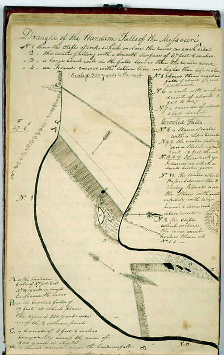
“Draught of the Handsom Falls”
To see labels, point to the image.
Missouri Historical Society, St. Louis.
Clark made this diagram of the “Handsom Falls of the Missouri” during late June and early July, 1805. Crooked Falls are at “B” at the lower edge of this map.[9]The original is in Voorhis #1, a codex in the Clark Family Collection, William Clark Papers, at the Missouri Historical Society, St. Louis. Photographic copy by David Schultz, 1997; NS 21278, … Continue reading
On the night of 17 June 1805, Clark, with Alexander Willard, John Colter, perhaps Joseph Field, and two others, camped at the mouth of a deep ravine below the south end of Crooked Falls. The next morning, continuing their systematic and detailed survey, the six men
Set out early and arrived at the second great Cataract a[t] about 200 yds above the last of 19 feet pitch . this is one of the grandest views in nature and by far exceeds any thing I ever Saw. the Missouri falling over a Shelveing rock for 47 feet 8 Inches with a Cascade &c of 14 feet 7 Inches above the Shoot for a 1/4 mile decended the Clift below this Cateract with ease measured the hight of the purpendicular fall of 47 feet 8 Inches[10]Forty-two feet, according to the Pacific Railroad Survey of the early 1850s. Isaac I. Stevens, Narrative and Final Report of Explorations for a Route for a Pacific Railroad, near the Forty-Seventh … Continue reading at which place the river is 473 yards wide as also the hight of the Cascade &c. a continued mist quite across this fall
The ‘Shineing Mountains’
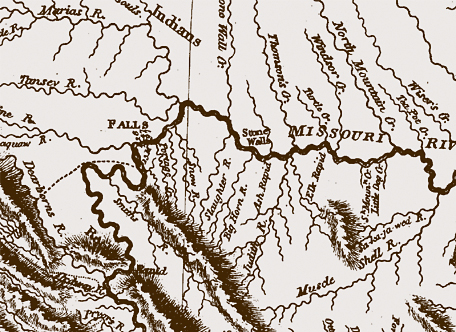
One of the most encouraging sights in the neighborhood was the snow on the surrounding mountains, which jibed with another feature of Evans’s map. On 20 June 1805, Clark observed:
Mountains to the South & S. E. of us Sometimes Snow. at present there is no Snow on those mountains; that which covered them a fiew days ago has all disappeared. the Mountains to the N. W. and West of us are Still entirely Covered are white and glitter with the reflection of the Sun. . . . I have thought it probable that these mountains might have derived their appellatin of Shineing Mountains, from their glittering appearance when the Sun Shines in certain directions on the Snow which Cover them.
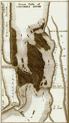
Clark’s Map of the Great Falls of the Columbia
To see labels, point to the map.
Phillips Collection, Mansfield Library Archives, The University of Montana, Missoula. Engraving from History of an Expedition under the Command of Captains Lewis and Clark . . . (1814) Vol. 2, facing page 31.
As challenging as the question of how Clark measured the falls of the Missouri may be, a more important question is Why? What compelled him to spend so much time and exert so much effort—even to risking his life—to go to such “great pains and accuracy,” mixing rough guesses with calculations so compulsively precise as 87 feet, ¾ of an inch?
Why Map the Falls?
Clark drew similarly detailed maps of both the Great Falls and the Cascades of the Columbia that, together with the Short and Long Narrows, made up a 55-mile stretch of falls, rapids and “shoots” that challenged the men’s courage and endurance. But owing to the urgency of reaching the ocean before winter began, the crowds of people that lined the banks, and perhaps above all the apparent pointlessness of the exercise, he included only a few perfunctory measurements on those two maps.
First, he did it in conscientious obedience to an order from his commander-in-chief to take observations “with great pains & accuracy.” The Great Falls of the Missouri comprised the most remarkable of all the “remarkeable points” he described and mapped.[11]Jefferson’s orders to Lewis said nothing specifically about mapping, but emphasized celestial observations, which made mapping the only logical mode for placing those “remarkeable … Continue reading Second, it was his obeisance to Enlightenment Science, his duty as a “philosopher,” a “lover of knowledge.” His job, like Lewis’s, was to measure, to count, and to sum up all he saw—to recognize order in the wilderness. This exercise at the falls of the Missouri constituted Clark’s most extensive single scientific observation. It was fully as meticulous as any of Lewis’s botanical or biological descriptions, such as those of the camas and the grizzly bear.
Finally, his measurements outlined the full dimensions of his and Lewis’s monumental misunderstanding of all the reports they had heard concerning “the fall” or “the cascade” of the Missouri.[12]See John Logan Allen, Lewis and Clark and Image of the American Northwest (New York: Dover, 1975), 43–44, 245–247. The 22 consecutive rapids and falls added up to 14-3/4 miles and 27 poles in extent; the aggregate height of the 22 consecutive rapids and falls came to 360 feet 2-3/4 inches, by Clark’s estimate. As yet the explorers had no clear understanding of what barriers that lay ahead, but this experience made them fear the possibility of similar misapprehensions about the very word “waterfall” until the day they reached tidewater on the Columbia River. Meanwhile, for their generation at least, the Falls of the Missouri clearly were an insurmountable impediment to the usual modes of commerce. At this very time and place, dreamers were awakened from the centuries-long fantasy of a Northwest Passage.
Clark’s Heights
The map of the Northwest that William Clark drew to accompany Nicholas Biddle’s paraphrase of his and Meriwether Lewis‘s journals was engraved by Samuel Lewis (1754?-1822; no relation to Meriwether), a draftsman and engraver in Philadelphia.[13]Donald Jackson, ed., Letters of the Lewis and Clark Expedition with Related Documents, 1873-1854 (2 vols., Urbana: University of Illinois Press, 1978), 2:603n. It was one of the most important outcomes of the expedition, at least in the short term, for it supplied a new cartographic picture of Northwestern geography that served travelers until after the middle of the 19th century.[14]The importance of Clark’s 1814 map is summarized in Gary E. Moulton, ed., The Journals of the Lewis and Clark Expedition (13 vols., Lincoln: University of Nebraska Press, 1983-2001), 1:13. See … Continue reading
In this detail, Clark’s “26” refers to the “Upper Pitch,” later called Black Eagle Falls, which he measured at precisely 26 feet, 5 inches. The figure “47” refers to the “Beautiful Cascade,” later named Rainbow Falls, which he calculated at 47 feet 8 inches.
The third figure stands for the “Great Falls,” shown in Clark’s sketch as 87 feet and three-quarters of an inch in height. In his route map for 13 June 1805–16 July 1805, it apparently was first written as “97 feet ¾ of an inch,” with the nine later modified to read as an 8. It is also 87 feet ¾ of an inch in the maps Clark prepared in 1833 for Prince Maximilian.[15]Moulton, Atlas map 54. The Clark-Maximilian map that includes the falls is Atlas map 61. However, in Clark’s 1810 manuscript draft of the simplified 1814 published version, it is clearly written “97 feet.” Upon first seeing the fall on 13 June 1805, Lewis estimated its height at eighty feet. A party of tourists who visited it in 1868 understood the height was 84 feet. The Stevens Railroad Survey of 1853 declared it to be 76 feet,[16]Isaac. I. Stevens (1818-1852), Narrative and Final Report of Explorations for a Route for a Pacific Railroad, near the Forty-Seventh and Forty-Ninth Parallels of North Latitude, from St. Paul to … Continue reading and although the engineer who designed the first dam that was built at the upper fall in 1890 announced that the actual height of each of the falls “did not vary six inches from the measurement given by Capt. Clark the engineer of the expedition,”[17]Paris Gibson, “The Falls of the Missouri—Their Past, Present and Future,” Rocky Mountain Magazine, Vol. 1, No. 1 (September 1900), p. 24. when the Ryan Dam was built in 1940, the working height of the fall was measured as 78 feet.
Actual Heights
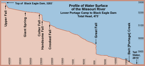
The accurate measurement of a series of falls, cascades and rapids as complex as the Falls of the Missouri is correspondingly complicated. William Clark estimated the total descent at 360 feet, 2¾ inches, which was close enough for simply descriptive purposes. For specific practical purposes, such as the development of water power to turn turbines that produce electricity, other factors must be considered.
This diagram is based on a drawing prepared in 1909 for the Great Falls Water Power and Townsite Company by an engineer by the name of Charles T. Main. The scale along the bottom margin indicates the distance in thousands of feet from the Great Fall upstream to the upper fall (Black Eagle Fall) and downstream to the vicinity of the lower portage camp. The crest of the Black Eagle Dam defines the upper limit of the “head,” or column of water pressure that ends at the “tail water.” The head is the total height, expressed in feet, of the column of water between the crest of Black Eagle Dam and the tail water. In 1909 the potential head at the falls of the Missouri totalled 473 feet, more than twice the head of water available at the Niagara Falls.
In the first decades of the nineteenth century the technology for harnessing water power was limited to an output of less than ten horsepower per water wheel. Lewis and Clark could scarcely have imagined the engineering necessary to harness the power of the falls of the Missouri. Look at it this way: The principle of the dynamo was discovered in 1830. Clark, who may not even have heard of it, was sixty years old; Patrick Gass was 59; Nathaniel Pryor, 58; Alexander Willard, 52; George Shannon, 51. Not until sixty years later would electricity be produced by turbine-driven generators. When the first Black Eagle Dam was completed in 1890, it worked on a pressure head of only 39 feet. Part of its output was used to produce some direct-current electricity for local use; the rest was mechanically transmitted to riverbank factories in the old-fashioned way–by means of rope drives.
Notes
| ↑1 | Photographed by Cary Horton; image 2002-NS 27638. |
|---|---|
| ↑2 | Paul Russell Cutright, A History of the Lewis and Clark Journals (Norman: University of Oklahoma Press, 1976), 117-120. |
| ↑3 | A. P. Nasatir, ed., Before Lewis and Clark: Documents Illustrating the History of the Missouri 1785 -1804 (2 vols., Lincoln: University of Nebraska Press, 1990), 2:498. |
| ↑4 | See James P. Ronda, “‘A Chart in his Way’: Indian Cartography and the Lewis and Clark Expedition.”Great Plains Quarterly, 4 (Winter 1984), 43-53. |
| ↑5 | Lewis ultimately left “Jefferson’s” river—today’s Beaverhead River—today’s at the forty-fifth parallel and turned westward. He did not know he was still 128 river miles from the Missouri’s ultimate source. Nor did he have any reason to care, since he knew from Sacagawea‘s assurances, as well as from the heavily traveled Indian road leading up today’s Horse Prairie Creek, that he was as close to the waters of the Columbia River as the Missouri would lead him. |
| ↑6 | From Paul Allen, ed., History of the expedition under the command of Captains Lewis and Clark, to the sources of the Missouri, thence across the Rocky Mountains and down the river Columbia to the Pacific Ocean. Performed during the years 1804-5-6. By order of the government of the United States. (2 vols., Philadelphia: Bradford and Inskeep, 1814), Plate 3. |
| ↑7 | Noah Webster, A Compendious Dictionary of the English Language (1806; reprint, New York: Crown Publishers, 1970). |
| ↑8 | A measure of Lewis’s state of mind during this period of the journey is suggested by the comment he recorded more than six weeks later, on 24 June 1805: “I fear every day that we shall meet with some considerable falls or obstruction in the river notwithstanding the information of the Indian woman to the contrary.” |
| ↑9 | The original is in Voorhis #1, a codex in the Clark Family Collection, William Clark Papers, at the Missouri Historical Society, St. Louis. Photographic copy by David Schultz, 1997; NS 21278, copyright 1997. |
| ↑10 | Forty-two feet, according to the Pacific Railroad Survey of the early 1850s. Isaac I. Stevens, Narrative and Final Report of Explorations for a Route for a Pacific Railroad, near the Forty-Seventh and Forty-Ninth Parallels of North Latitude, from St. Paul to Puget Sound (Washington, D.C., 1855), 173. |
| ↑11 | Jefferson’s orders to Lewis said nothing specifically about mapping, but emphasized celestial observations, which made mapping the only logical mode for placing those “remarkeable points” in meaningful relationships with each other. Specifically, the “remarkeable points” Jefferson mentioned were mouths of rivers, rapids, islands, “& other places & objects distinguished by such natural marks & characters of a durable kind, as that they may with certainty be recognised hereafter.” Donald Jackson, ed., Letters of the Lewis and Clark Expedition with Related Documents, 1783–1854 (2nd ed., 2 vols., Urbana: University of Illinois Press, 1978), 1:61–62. |
| ↑12 | See John Logan Allen, Lewis and Clark and Image of the American Northwest (New York: Dover, 1975), 43–44, 245–247. |
| ↑13 | Donald Jackson, ed., Letters of the Lewis and Clark Expedition with Related Documents, 1873-1854 (2 vols., Urbana: University of Illinois Press, 1978), 2:603n. |
| ↑14 | The importance of Clark’s 1814 map is summarized in Gary E. Moulton, ed., The Journals of the Lewis and Clark Expedition (13 vols., Lincoln: University of Nebraska Press, 1983-2001), 1:13. See also John Logan Allen, Lewis and Clark and the Image of the American Northwest (New York: Dover, 1975), 375-376. In this detail, the “13 M” may be an engraver’s error. According to Clark’s survey the portage route was eighteen miles long. Clark’s original draft, drawn in 1810, merely indicated a double dotted line labeled “portage.” |
| ↑15 | Moulton, Atlas map 54. The Clark-Maximilian map that includes the falls is Atlas map 61. |
| ↑16 | Isaac. I. Stevens (1818-1852), Narrative and Final Report of Explorations for a Route for a Pacific Railroad, near the Forty-Seventh and Forty-Ninth Parallels of North Latitude, from St. Paul to Puget Sound (Washington, D.C.: Thomas H. Ford, 1855), 173. |
| ↑17 | Paris Gibson, “The Falls of the Missouri—Their Past, Present and Future,” Rocky Mountain Magazine, Vol. 1, No. 1 (September 1900), p. 24. |
Experience the Lewis and Clark Trail
The Lewis and Clark Trail Experience—our sister site at lewisandclark.travel—connects the world to people and places on the Lewis and Clark Trail.
Discover More
- The Lewis and Clark Expedition: Day by Day by Gary E. Moulton (University of Nebraska Press, 2018). The story in prose, 14 May 1804–23 September 1806.
- The Lewis and Clark Journals: An American Epic of Discovery (abridged) by Gary E. Moulton (University of Nebraska Press, 2003). Selected journal excerpts, 14 May 1804–23 September 1806.
- The Lewis and Clark Journals. by Gary E. Moulton (University of Nebraska Press, 1983–2001). The complete story in 13 volumes.

