Crossing the Dearborn River
This stream, Lewis wrote on 8 July 1806, “comes form the S. W. out of the mountains which are about 5 Ms. to our left. the bed of the river is about 100 yds. wide tho’ the water occupys only about 30 yds. it appears to spread over it’s bottoms at certain seasons of the year and runs a mear torrant tearing up the trees by the roots which stand in it’s bottom” He called it “torrant” river, after its apparent character.
Obviously, he didn’t recognize this as the upper stretch of the “considerable river . . . about 80 yds. wide” he had seen on 18 July 1805 near the “first gate” of the Rocky Mountains. Its current, he had noted then, “is rapid and water extreamly transparent; . . . it appears as if it might be navigated but to what extent must be conjectural.” That was the “handsome bold and clear stream we named in honour of the Secretary of war calling it Dearborn’s river.”
Either Lewis himself realized the confusion, or discussed the matter with Clark later, for Clark correctly named it on the map he drew of the shortcut.
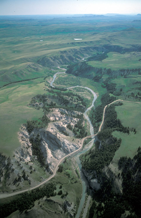
At center foreground of Fig. 1, the Stearns-to-Augusta road crosses the Dearborn River approximately where the Old North Trail crossed it. The river turns toward the southeast just above the middle of the photo. On the horizon at right of center is Square Butte or, as the captains called it, “Fort Mountain” [Square Butte].
Figure 2
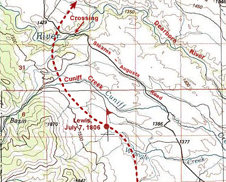
Dearborn Crossing

TOPO!® © 2000 National Geographic.
The Medicine (Sun) River
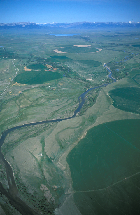
Figure 3
Farmers and ranchers who settled in the Sun River valley in the 1890s began impounding reservoirs and digging irrigation systems to deliver water supplies to hayfields steadily throughout the growing season. Those systems consisted of deep trunk ditches feeding shallower laterals where headgates controlled the rate of surface distribution to the crops. Today, a variety of more efficient systems, fed from either ditches or wells, include center-pivot sprinklers such as those that created the circular patterns pictured above.[1]Descriptions and photographs of the various types of irrigation systems now in use will be found on the University of Georgia College of Agricultural and Environmental Sciences, Cooperative Extension … Continue reading Unfortunately, they are severely reducing the level of the aquifer they drawn upon.
Shortly after crossing the Dearborn River, Lewis saw that the Indian road “continued along the foot of the mountain to the West of north”—possibly the ancient way now known as the Old North Trail—so he and his men cut northeast across the “tolerably level” plain toward the Sun (“Medicine”) River. His aim was to “hunt down it to it’s mouth in order to procure the necessary skins to make geer, and meat for the three men whom we mean to leave at the falls.” He and Clark had first heard of this river at Fort Mandan during the winter of 1804-05. Above the Great Falls of the Missouri,
a large stream called Mah-pah-pah,-ah-zhah, or Medecine river falls in on the N. side. This river heads in the Rocky Mountains opposite to a river which also takes it’s rise in the same mountains and which running West discharges itself into a large river, which passes at no great distance from the Rocky mountains, running from N to South. It passes through a mountainous, broken and woody country. Not navigable in consequence of it’s rapidity and shoals.
He himself had assessed the qualities of the lower few miles of the Medicine River on the previous 14 June 1805:
found it a handsome stream, about 200 yds. wide with a gentle current, apparently deep, it’s waters clear, and banks which were formed principally of darkbrown and blue clay were about the hight of those of the Missouri or from 3 to 5 feet; yet they had not the appearance of ever being overflown, a circumstance, which I did not expect so immeidately in the neighbourhood of the mountains, from whence I should have supposed, that sudden and immence torrants wouild issue at certain seasons of the year; but the revverse is absolutely the cast. I am therefore compelled to beleive that the snowey mountains yeald their warters slowly, being partially effected every day by the influence of the sun only, and never suddonly melted down by haisty showers of rain.
Credits: Alan H. Hartley, linguistics, Detroit, Michigan; Robert N. Bergantino, geologist, Western Montana School of Mines and Geology; Marilyn Hudson, Curator, Three Tribes Museum, Newtown, North Dakota; Jack Lepley, manager, Museum of the Northern Great Plains, Fort Benton, Montana; David Alt, Professor Emeritus, Geology Department, The University of Montana, Missoula.
Notes
| ↑1 | Descriptions and photographs of the various types of irrigation systems now in use will be found on the University of Georgia College of Agricultural and Environmental Sciences, Cooperative Extension Service web site, at http://pubs.caes.uga.edu/caespubs/pubcd/B882.htm. |
|---|
Experience the Lewis and Clark Trail
The Lewis and Clark Trail Experience—our sister site at lewisandclark.travel—connects the world to people and places on the Lewis and Clark Trail.
Discover More
- The Lewis and Clark Expedition: Day by Day by Gary E. Moulton (University of Nebraska Press, 2018). The story in prose, 14 May 1804–23 September 1806.
- The Lewis and Clark Journals: An American Epic of Discovery (abridged) by Gary E. Moulton (University of Nebraska Press, 2003). Selected journal excerpts, 14 May 1804–23 September 1806.
- The Lewis and Clark Journals. by Gary E. Moulton (University of Nebraska Press, 1983–2001). The complete story in 13 volumes.


