Under cloudy skies the expedition towed their flotilla into one of the most famous riverscapes on the Missouri, the White Cliffs.
The Missouri “breaks” extend, river distance (and the river was then and is still the only way they can be traversed), for about four hundred miles. They were christened mauvaises terres by the Métis, but the English word is better because much of the area is timbered and–though the 130-mile-long reservoir of Fort Peck Dam has flooded some of the best land–there still are thousands of acres of rich grass. But there are badlands, too–mile after mile of sandstone towers, knobs, ridges; gullies gray and white and red; rock platforms stark against the sky, looking as if they had been erected for sacrifices to the ancient gods. As the sun descends the hot wind dies and then comes the miracle of color, purple and yellow and flame and unnamed mutations, merging at last in a golden haze over the muddy Missouri, suddenly transformed into a ribbon of silver.
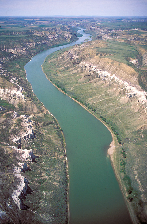
Figure 1
The White Cliffs by Air
Upper Missouri National Wild and Scenic River
View west, upstream
© 2000 Airphoto—Jim Wark.
Under cloudy skies on the morning of 31 May 1805, the expedition “proceeded at an early hour,” and roped their flotilla of six cottonwood dugout canoes and two big pirogues into one of the most famous riverscapes on the Missouri. Although they had spent several days among the rugged breaks of the Missouri River, this new landscape took them by surprise. Lewis was enchanted by the myriad aspects of it all.
His pen followed the passions of his mind from Providential architecture and Masonic symbolism,[2]See Lewis as Master Mason. through objective geological analysis, to natural history. He reasoned, correctly, that water had “woarn”–hear him pronounce it wo-arn–”it into a thousand groteasque”–again, listen to him; grow-tay-esk–”figures, which with the help of a little imagination and an oblique view at a distance, are made to represent elegant ranges of lofty freestone buildings, having their parapets well stocked with statuary.” He made notes about the cliff swallows, bighorn sheep, limber pine, and “the most beautifull fox that I ever beheld.” His curiosity drove him to find out what the land was like above and beyond this grand array: “[T]he earth on the top of these Clifts is a dark rich loam, which forming a graduly ascending plain extends back from½ a mile to a mile where the hills commence and rise abruptly to a hight of about 300 feet more.”
His men, meanwhile, clad only in breechcloths, are enduring less romantic realities that also challenge his pen:
The obstructions of rocky points and riffles still continue as yesterday; at those places the men are compelled to be . . . in the water even to their armpits, and the water is yet very could, and so frequent are those point[s] that they are one fourth of their time in the water, added to this the banks and bluffs along which they are obliged to pass are so slippery and the mud so tenacious that they are unable to wear their mockersons, and in that situation draging the heavy burthen of a canoe and walking occasionally for several hundred yards over the sharp fragments of rocks which tumble from the clifts and garnish the borders of the river; in short their labour is incredibly painfull and great, yet those faithfull fellows bear it without a murmur.
One of those subaqueous impediments is visible at lower right in the above photograph. Notice the dark shallow spot at the outlet of the little gully that snakes down from the high plains, where annual spring freshets have surrendered their terrestrial burdens to the mighty Missouri.
(Lewis’s journal entries beginning with his departure from Fort Mandan strike the reader as drafts conceived and crafted–more or less at leisure–for the post-expedition documentary essay that was steadily taking shape in his imagination. After his arrival at the White Cliffs they take on heightened eloquence and grace, inspired by the ongoing thrill of unexpected discoveries. To our everlasting regret, the opus he had in mind was doomed to be stillborn.)
Karl Bodmer’s Illustrations
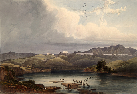
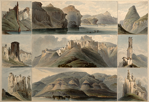
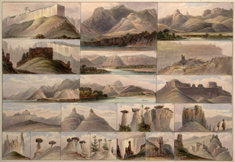
Figure 2
Artist Karl Bodmer‘s Water-Level Views (1833)
Rare Book and Special Collections Division, Library of Congress.
Prince Maximilian von Wied-Neuwied, who conducted a private scientific exploration of the upper Missouri in 1833-34, thought of them as “white mountain castles with brownish roofs. . . . As soon as one comes closer, the resemblance naturally vanishes; but from Mr. Bodmer’s sketches one will easily see that from a distance a great resemblance exists.” Bodmer drew the following 29 closeups of details among the White Cliffs, which were reworked into aquatints for an atlas that was published in the 1840s.[3]Voyage dans l’intérieur de l’Amérique du Nord, exécuté pendant les années 1832, 1833 et 1834, par le prince Maximilien de Wied-Neuwied (Paris: A Bertrand, 1840-43), Plates 34, 35, 37.
The White Cliffs still challenge the imagination to match a Lewis’s pen or a Bodmer’s brush. In River-Horse, William Least Heat-Moon, soaring through the scene with his senses white-hot, calls it “a welter of rocks worn into oddities, grotesqueries, wierdities, nature gone whimsical if not deranged, a realm created by a fevered dreamer. . . . a madscape hanging on the drop edge of a yonder.” But viewed from a quarter of a mile up in the sky, the chalky white line in the green-and-tan landscape relieves the imagination of all responsibility for participation. The welter is calmed, the magic dispelled. Those are just rocks.The glistening, white-ish rocks from which these formations take their common name are layers of sandstone deposited by the great inland sea that covered much of North America during the Cretaceous Period.
The White Cliffs is a High Potential Historic Site along the Lewis and Clark National Historic Trail managed by the U.S. National Park Service. It is part of the Upper Missouri River Breaks National Monument managed by the Bureau of Land Management.—ed.
From Discovering Lewis & Clark from the Air
Photography by Jim Wark
Text by Joseph Mussulman
Reproduced by permission of Mountain Press
Notes
| ↑1 | Joseph Kinsey Howard, Strange Empire: A Narrative of the Northwest (New York: William Morrow, 1952), 339. |
|---|---|
| ↑2 | See Lewis as Master Mason. |
| ↑3 | Voyage dans l’intérieur de l’Amérique du Nord, exécuté pendant les années 1832, 1833 et 1834, par le prince Maximilien de Wied-Neuwied (Paris: A Bertrand, 1840-43), Plates 34, 35, 37. |
Experience the Lewis and Clark Trail
The Lewis and Clark Trail Experience—our sister site at lewisandclark.travel—connects the world to people and places on the Lewis and Clark Trail.
Discover More
- The Lewis and Clark Expedition: Day by Day by Gary E. Moulton (University of Nebraska Press, 2018). The story in prose, 14 May 1804–23 September 1806.
- The Lewis and Clark Journals: An American Epic of Discovery (abridged) by Gary E. Moulton (University of Nebraska Press, 2003). Selected journal excerpts, 14 May 1804–23 September 1806.
- The Lewis and Clark Journals. by Gary E. Moulton (University of Nebraska Press, 1983–2001). The complete story in 13 volumes.


