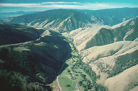
Salmon River and Tower Creek Valleys
To see labels, point to the image.
© 2001 Airphoto, Jim Wark. All rights reserved.
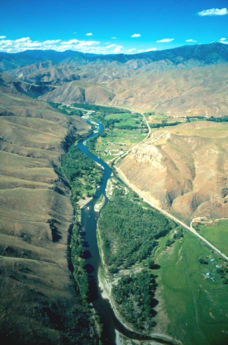
This view looks toward true north down the Salmon River from the upper end of the broad bottom now known as Big Flat.
They were on the road before sunrise on the 31st. The rapport they had established with the Lemhi Shoshones since Lewis’s first tentative meeting two weeks before paid off when Clark “met an Indian on horse back who fled with great Speed to Some lodges below & informed them that the enemis were Coming down, armd with guns &c. the inhabitents of the Lodges undisceved him.” That afternoon the Corps turned up Tower Creek to detour around the rugged terrain near the river that Clark had found so difficult. They camped about four miles up the creek, taking advantage of two vacant Shoshone lodges.
Returning from his reconnaissance of the Salmon River canyon on 26 August 1805, Clark camped in the vicinity of the Shoshone fish weirs five miles south of the confluence of the two forks of Lewis’s River, and waited for Lewis and his contingent to join him with the horses and baggage. On the 29th Clark left his baggage in the care of two men and hurried on up the East Fork (Lemhi River) to Lewis’s camp at the upper Shoshone village. The next morning the captains bought two more horses and set off down the Lemhi valley with Toby, his three sons, and one other Indian in the lead. At the same time most of the Shoshones “Set out over to the waters of the Missouri,” to meet the Salish and head toward their buffalo hunting grounds near the Three Forks of the Missouri.
Beyond the mouth of Tower Creek the Salmon winds tortuously through a seven-mile-long canyon where the vertical walls at that time crowded the riverbanks so tightly in several places that Clark and his party were compelled to clamber over “four mountains verry Steap high & rockey” on the east side. Indeed, “the assent of three was So Steap that it is incrediable to describe.”
Rugged Hills Above Tower Creek
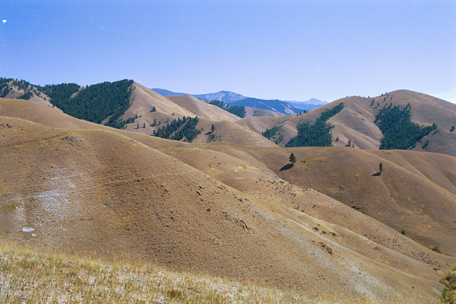
“High ruged hills”
© 2002 VIAs Inc.
On the blue-gray southeast horizon at the center of the photo, the Bitterroot Range defines the Continental Divide. After leaving their camp on Tower Creek on the morning of 31 August 1805, the Corps climbed over the next-closest ridge, through the upper reaches of Kriley Creek, surmounted the ridges separating the two forks of Fourth of July Creek, and dropped down through the forested northwest slopes above Wagonhammer Creek. Descending Wagonhammer Creek a short distance, they turned up Burns Gulch (seen in part in the extreme lower right corner of the photo), and reached the ridge out of the picture at lower left.
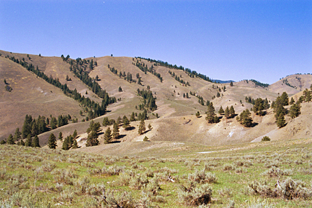
“Steep as the roof of a house”
© 2002 VIAs Inc.
Looking west-by-northwest, this view was taken from the ridge between upper Burns Gulch (behind the camera) and upper Silverlead Creek. The Indian road went down the draw beyond the left edge of the photo, turned north up Little Silverlead Creek, then northwest up “a mountain nearly as steep as the roof of a house,” in Whitehouse’s words. It passed through the gap in the ridge at right of center, and descended to the North Fork of the Salmon by about 3:00 in the afternoon.
Tower Creek Geology
Upon reaching Tower Creek in the evening of 21 August 1805, Clark described the cliff near which he camped, relying as usual on his limited experience and his unassisted senses to classify the rocks by color and texture. “This Clift is of a redish brown Colour the rocks which fall from it is a dark brown flint tinged with that Colour. Some Gullies of white Sand Stone and Sand fine & a[s] white as Snow.” In fact, no flint exists in or below that cliff. It is an outcrop of argillite, which is extremely hard mudstone. This argillite is probably about one billion years old, give or take a hundred million years or so. It belongs to one of the several Belt formations, which together cover enormous areas of western and southwestern Montana, central and northern Idaho, and southeastern British Columbia. Lewis and Clark and their party surely saw thousands of outcrops of Belt formations as they trekked through the Northern Rocky Mountains.
The white sandstone and sand Clark saw above the argillite in the cliff are part of the Carmen formation, which geologist A. L. Anderson studied in 1956 and named after nearby Carmen Creek. It is a deposit of pale sediments and volcanic ash laid down on the land in early Tertiary time, or approximately 50 million years ago.
Judging Flint
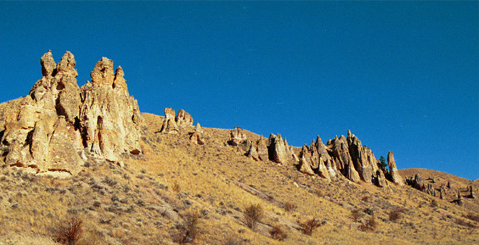
Two miles up a “run” on a heading N. 35° E, and two more N. 10° E took the Corps past this “remarkable rock resembling Pirimids on the Left Side.” The washing away of sedimentary deposits by an older and much larger Salmon River has left the harder, granite-like volcanic rock to be eroded by water and rain into fantastic shapes along the margins of this 8-mile-long drainage that suggested to Clark the name “Tower Creek,” by which it is still called.
Of course Clark, like all the other men in the Corps, but especially the hunters, had to be a good judge of the kind of stone needed in a flintlock gun. Lewis had included “500 best Flints” in his pre-expedition shopping list, by which he probably meant imports from England. On 18 May 1803, he received 500 rifle flints and 125 musket flints from the Arsenal. He may have bought more in St. Louis, as the party grew from the original 15 men planned, to more than forty.[1]Michael Carrick, personal communication, 11 July 2004. It is likely that more gun “flints” were purchased in St. Louis during the winter of 1803-1804. If so, they might have been local … Continue reading By the time they got back to the east side of the Bitterroot Range in 1806, they must have been nearing the end of their supply. Clark’s instructions to Sergeant Pryor, whose mission was to trail their horses from the middle Yellowstone River up to Fort Assiniboine in Canada to trade for services and supplies, included the purchase of gunflints as the highest priority.
Along the trail the men occasionally tested rocks with a piece of steel to see how “flinty” they were. Of the “confused and broken masses of stone” on the Salmon River’s banks below the forks, Clark told Lewis (23 July 1805) that they were “white or brown and towards the base of a grey colour and so hard that when struck with a steel, yeald fire like flint.” Clark’s closing phrase suggests that he realized it was not true flint. In fact, the rocks in the depths of the canyon are of the sedimentary and volcanic sort; they contain no flint. Although Indians sometimes resorted to argillite and quartzite for the making of arrow points, the results were consistently crude and less than satisfactory.
Actually, flint is a black or very dark brown variety of chert. It commonly occurs in many kinds of sedimentary rocks, but most notably in limestone, and chiefly in Europe. Chert is a microscopically crystalline variety of quartz with a waxy appearance. Given a sharp blow with another hard instrument such as the butt of an elk antler—a skill called knapping—it breaks along curving surfaces to produce razor-like edges. Some of the limestone formations that the Corps of Discovery crossed in western Montana contain round nodules of dark chert that they could have mistaken for genuine flint.
Lewis and Clark often used the word flint merely in a general sense, as they also used the terms granite, limestone, sandstone, and “freestone.” For instance, in the abandoned parfleche Drouillard brought him from Shoshone Cove on the 22nd, Lewis found “some flint and the instrument of bone for manufactureing the flint into arrow points. some of this flint was as transparent as the common black glass and much of the same colour easily broken, and flaked of[f] much like glass leaving a very sharp edge.” The latter would have been obsidian, though Lewis did not use the term. The rock that Indians used for cutting tools and arrow points was—depending on trade or local resources—obsidian,[2]Visitors to Yellowstone National Park may recall the 200-foot-high outcrop of obsidian 11 miles south of Mammoth Hot Springs. Archaeological evidence has indicated that cutting tools possibly mined … Continue reading chalcedony, chert, quartzite, jasper, agate, or ignimbrite.[3]Noah Webster, in his Compendious Dictionary of the English Language (Boston, 1806), defined flint simply as “a very hard kind of stone.” Chert was “a kind of flint, flints lying in … Continue reading All are hard, and all can be fractured into small pieces with sharp edges. See also Kirwan’s Elements of Mineralogy.
North Fork of the Salmon River
North Fork Salmon River
To see labels, point to the image.
© 2001 Airphoto, Jim Wark. All rights reserved.
This view looks south down the lower reaches of the North Fork—which Lewis and Clark called Fish Creek—of the Salmon River, which flows from upper left toward the confluence at upper center, then westward (right of photo).
On 1 September 1805, the Corps left their camp four miles up Tower creek and “proceeded on” reported Private Whitehouse, “over verry high mountains which was verry bad for our horses to climb up and down,” and crossed “Several large creeks the water of which is verry cold.” That afternoon they crossed a mountain “nearly as Steep as the roof of a house”–so steep, in fact, that “one of the horses fell backward and roled over,” reported Sgt. Ordway.[4]See also Horse Packing.
When Clark first arrived at the forks of the Salmon River on 22 August 1805, he found several families of Indians who were sun-drying fish and berries. “We allarmed them verry much as they knew nothing of a white man being in their Countrey,” he reported. “They offered every thing they possessed (which was verry littl) to us, Some run off and hid in the bushes . . . . I gave a fiew Small articles to those fritened people which added verry much to their pasification but not entirely as Some of the women & Childn. Cried dureing my Stay of an hour at this place.” When his Shoshone guide, Toby, caught up with him, he and his party proceeded three miles down the Salmon below the forks, and camped. The next morning they made a little more than four miles before the going got too difficult for the horses to negotiate safely, so Clark took three of the men with him and followed Toby another sixteen miles downriver.
Clark kept his eyes peeled for details along the way. Among other things, on the 22nd he noticed a “Bird of the wood pecker kind which fed on Pine burs its Bill and tale white the wings black every other part of a light brown, and about the Size of a robin.” It was the first observance of a new species of the crow family, now known as “Clark’s nutcracker.”
On 1 September they camped for the night on the North Fork, about 3-1/2 miles above the Indian village. The best part of the day was the harvest of “the greatest quantity and best service berries I had ever seen before,” Sgt. Gass recalled, “and abundance of choak-cherries.” To top off the day they boiled some, which, in Ordway’s opinion, “eat verry well.”
The North Fork of the Salmon begins only a little over 20 miles north, up the canyon, where the West Fork converges with a stream now called Moose Creek. Some students of this episode believe Toby took the Corps up the West Fork to their campsite near the divide on 3 September 1805. Others believe they took the east fork, now Moose Creek—the same drainage where U.S. Highway 93 was built more than a century after the explorers passed through. In either case, there was no road to follow, so they scrambled and bushwacked up the narrow canyon toward the Bitterroot divide.
Notes
| ↑1 | Michael Carrick, personal communication, 11 July 2004. It is likely that more gun “flints” were purchased in St. Louis during the winter of 1803-1804. If so, they might have been local chert rather than imported gunflint. |
|---|---|
| ↑2 | Visitors to Yellowstone National Park may recall the 200-foot-high outcrop of obsidian 11 miles south of Mammoth Hot Springs. Archaeological evidence has indicated that cutting tools possibly mined there by the Tukadikas, the “sheepeater” band of Shoshones, were once traded at least as far east as Ohio. Obsidian results when lava cools faster than crystals can form. |
| ↑3 | Noah Webster, in his Compendious Dictionary of the English Language (Boston, 1806), defined flint simply as “a very hard kind of stone.” Chert was “a kind of flint, flints lying in thin strata”; obsidian was “a silicious [sic] stone, black or grayish black”; jasper, “a beautiful white or green stone”; quartz, “a siliceous stone so hard as to emit sparks with steel”; agate, “a class of gems, of many varieties.” Siliceous—from silex, the Latin word for flint— meant “pertaining to silex, or the genus of silex, flinty.” None of the journalists ever used any of those terms, other than flint. Chalcedony and ignimbrite were not in Webster’s first dictionary. Chalcedony is the category of quartz that includes jasper, agate, and onyx. The volcanic rock ignimbrite consists of consolidated fragments of pumice. |
| ↑4 | See also Horse Packing. |
Experience the Lewis and Clark Trail
The Lewis and Clark Trail Experience—our sister site at lewisandclark.travel—connects the world to people and places on the Lewis and Clark Trail.
Discover More
- The Lewis and Clark Expedition: Day by Day by Gary E. Moulton (University of Nebraska Press, 2018). The story in prose, 14 May 1804–23 September 1806.
- The Lewis and Clark Journals: An American Epic of Discovery (abridged) by Gary E. Moulton (University of Nebraska Press, 2003). Selected journal excerpts, 14 May 1804–23 September 1806.
- The Lewis and Clark Journals. by Gary E. Moulton (University of Nebraska Press, 1983–2001). The complete story in 13 volumes.
