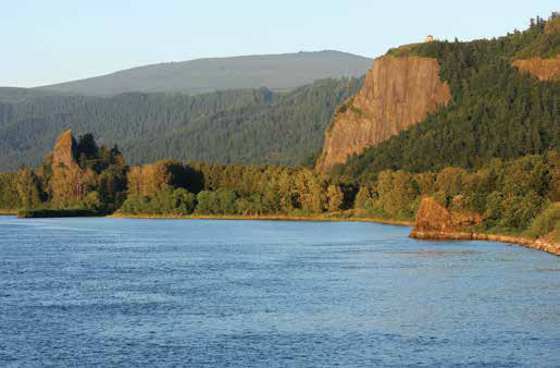
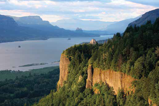
View of Rooster Rock (left) and Crown Point (right) where the expedition encamped on 2 November 1805. Described by Sgt. Patrick Gass as “a high peak resembling a tower of the south side,” Rooster Rock is compositionally identical to the Basalt of Rosalia flow of Crown Point and is interpreted to be part of a landslide block that slid down to its present position at the river’s edge.
Clark described the expedition’s 2 November 1805, encampment differently in his Elkskin-bound journal, and then in his notebook journal:
we Encamped behind a large rock in the Lard. Bend.
we encamped under a high projecting rock on the Lard. Side.
It is an interesting exercise to determine whether the captains and the corps were referring to Crown Point or Rooster Rock in their 2 November 1805, journal entries. The promontory of Crown Point comes to mind when Clark mentions in his notebook journal that the expedition camped “under a high projecting rock,” along with Sgt. John Ordway having the expedition “Camped under a verry Shelving clift on the Lard. Side.”[2]The author agrees with Moulton, Journals, 6:10n14 that the “high projecting rock” is Crown Point. No correlation between journal descriptions and Rooster Rock were made in the Moulton … Continue reading Precisely where they set up camp could be revealed in Clark’s Elkskin-bound journal when he noted the expedition encamped “behind a large rock,” as did Patrick Gass noting the expedition “encamped at a high peak resembling a tower of the south side.” The isolated pinnacle of Rooster Rock fits a “tower” description nicely and one can easily imagine the expedition encampment in the level glade between Rooster Rock and the vertical Crown Point cliff face; perhaps this was the encampment “green” that Whitehouse alluded to his 2 November 1805, original journal entry.
That Meriwether Lewis utilized Rooster Rock as an ad-hoc river gauge seems evident on the return journey:
[6 April 1806:] from the appearance of a rock near which we had encamped on the 3rd of November last [in error, it was 2 November 1805] I could judge better of the rise of the water than I could at any point below.
Careful comparison of the rock lithology of Rooster Rock and Crown Point have revealed that Rooster Rock is a landslide block off the face of Crown Point,[3]Wells, et al., “Gorge to the Sea,” 748. yet another example of the inexorable process of mass earth movements in the Columbia River Gorge, even though the intermediate landslide material between Crown Point and Rooster Rock has largely been swept away. And before we exit the Gorge, just as the expedition did when Clark noted on 2 November 1805, that “here the mountains leave the river on each Side,” it’s worth a diversion to discuss how an ancestral Columbia River channel became a towering cliff at Crown Point.
Ancestral Columbia River Channel
The waning rays of sunset highlight the dense Basalt of Rosalia that composes the upper section of the “high projecting rock” of Crown Point on the western end of the Columbia Gorge, now uplifted over 700 feet higher than its original position. This fifteen-million-year-old intra-canyon flow filled one of the ancestral Columbia River channels that preceded the modern river which ferried the Lewis and Clark expedition to the Pacific Ocean.[4]See Columbia River Basalts.
The captains would have been surprised to learn that certain stretches of the Columbia River had occupied several different channels preceding the river that ferried them westward,[5]The earliest of the last three identified paleochannels, estimated to have formed approximately 15.6 million years ago, extended from The Dalles to under the area of present-day Mount Hood, then … Continue reading and they unknowingly passed remnants of these earlier rivers. The captains had demonstrated an excellent faculty for recognizing “ancient beds of the river” along the Missouri River,[6]For examples of where the captains recognized “ancient beds of the river,” see pages 177-178 in John W. Jengo, “‘Mineral Productions of Every Kind’: Geological … Continue reading but the paleochannels of the Columbia River in the Gorge evaded recognition until the 1970s and 1980s. Only when geologists began thoroughly mapping unique types of basalt deposits that had flowed into and been cooled by water was it determined such deposits could be differentiated from the flows that had advanced over relatively dry land.
Because the ancestral Columbia River was the low point on the Columbia Plain, it was preferentially filled and erased by certain large-scale lava flows and other deposition events.[7]CRBG basalt flows filled the two earlier Columbia River canyons per Tolan and Beeson, “Intracanyon,” 463-477, and are called “intracanyon” flows for that reason. Cascadian … Continue reading The river, always unceasingly seeking a pathway to the sea across eruptive flood basalts and through the Miocene-age Cascade Mountains, shifted northward following each river channel-filling episode into relatively low-lying troughs to exploit older and weaker rocks proximal to the northern margin of the more-resistant Columbia River Basalt Group (CRBG) lava plain.[8]Tolan and Beeson, “Intracanyon,” 476. The ancestral Columbia River system could maintain a prevailing westward flow because of the continued subsidence of the Yakima Belt syncline, which … Continue reading The present-day Columbia River has sliced through some of the former river channels at certain locales, most notably at Mitchell Point (comprised of a canyon-filling basalt associated with the youngest ancestral river channel called the Bridal Veil channel) and Crown Point, part of the older ancestral Priest Rapids channel. So, when the expedition “encamped under a high projecting rock” at Crown Point on 2 November 1805, they were camping near the base of an uplifted 15-million year old Columbia River channel, one of the predecessor watercourses of their route westward.[9]This is technically called the Basalt of Rosalia intracanyon flow of the Priest Rapids Member, Wanapum Basalt, part of the material that filled the Priest Rapids ancestral Columbia River channel. Up … Continue reading
Notes
| ↑1 | John W. Jengo, “After the Deluge: Flood Basalts, Glacial Torrents, and Lewis and Clark’s “Swelling, boiling & whorling” River Route to the Pacific,” Part 2, We Proceeded On, November 2015, Volume 41, No. 4, the quarterly journal of the Lewis and Clark Trail Heritage Foundation. The original, full-length article is provided at https://lewisandclark.org/wpo/pdf/vol41no4.pdf#page=10. |
|---|---|
| ↑2 | The author agrees with Moulton, Journals, 6:10n14 that the “high projecting rock” is Crown Point. No correlation between journal descriptions and Rooster Rock were made in the Moulton editions so the author offers his interpretation herein. |
| ↑3 | Wells, et al., “Gorge to the Sea,” 748. |
| ↑4 | See Columbia River Basalts. |
| ↑5 | The earliest of the last three identified paleochannels, estimated to have formed approximately 15.6 million years ago, extended from The Dalles to under the area of present-day Mount Hood, then south-westward to Salem, Oregon. When volcanism destroyed that route, another channel (sometimes referred as the Priest Rapids channel) formed sometime between 15 and 14.5 million years ago with its head at present-day Mosier, Oregon, and ran through the Hood River Valley and Bull Run Watershed before exiting the future area of the Gorge at Crown Point. When this channel was obliterated by advancing Priest Rapids Member lava flows of the Wanapum Basalt, the third ancestral channel called the Bridal Veil channel was formed in the vicinity of Hood River past the northern fringe of Mt. Defiance and Larch Mountain to Bridal Veil. The Bridal Veil channel persisted some 10 million years up to approximately four to two million years ago primarily because there was a decrease in the frequency and volume of flood basalts, resulting in flows that either failed to reach or completely fill the channel. See Tolan, et al., “Neogene History—Part I,” 46:8, 93-94; and Reidel and Tolan, “Late Cenozoic Evolution,” 210-225. |
| ↑6 | For examples of where the captains recognized “ancient beds of the river,” see pages 177-178 in John W. Jengo, “‘Mineral Productions of Every Kind’: Geological Observations in the Lewis and Clark Journals and the Role of Thomas Jefferson and the American Philosophical Society in the Geological Mentoring of Meriwether Lewis,” in Robert S. Cox, ed., “The Shortest and Most Convenient Route: Lewis and Clark in Context,” Transactions of the American Philosophical Society, 95:5 (2004), 136-214. |
| ↑7 | CRBG basalt flows filled the two earlier Columbia River canyons per Tolan and Beeson, “Intracanyon,” 463-477, and are called “intracanyon” flows for that reason. Cascadian volcanism triggered high-alumina basalt flows that filled and capped the youngest ancestral channel (the Bridal Veil channel) and facilitated the shifting of the Columbia River northward again to its present-day position as the Gorge region was uplifted. See Tolan and Beeson, “Intracanyon,” 475-476; and also page 112 in Terry L. Tolan, Marvin H. Beeson, and Beverly F. Vogt, “Exploring the Neogene History of the Columbia River: Discussion and Geologic Field Trip Guide to the Columbia River Gorge—Part II Road Log and Comments,” Oregon Geology, 46:9 (September 1984), 103-112. |
| ↑8 | Tolan and Beeson, “Intracanyon,” 476. The ancestral Columbia River system could maintain a prevailing westward flow because of the continued subsidence of the Yakima Belt syncline, which essentially created a regional-scale (and downslope) gradient pathway for the river. See page 615 in Terry L. Tolan, Barton S. Martin, Stephen P. Reidel, James L. Anderson, Kevin A. Lindsey, and Walter Burt, “An Introduction to the Stratigraphy, Structural Geology, and Hydrogeology of the Columbia River Flood-Basalt Province: A Primer for the GSA Columbia River Basalt Group Field Trips,” in O’Connor, et al. Volcanoes to Vineyards, 599-643. |
| ↑9 | This is technically called the Basalt of Rosalia intracanyon flow of the Priest Rapids Member, Wanapum Basalt, part of the material that filled the Priest Rapids ancestral Columbia River channel. Up until recently, the date of this flow was consistently referenced as ca. 14.5 million years old in the technical literature, including many of the references cited in this article. However, a revised date of ca. 15 million years for this flow has been recently proposed so the author has referenced that date; see page 59 in the 2013 paper by Tiffany L. Barry, Simon P. Kelley, Stephen P. Reidel, Victor E. Camp, Stephen Self, Nicholas A. Jarboe, Robert A. Duncan, and Paul R. Renne, “Eruption Chronology of the Columbia River Basalt Group,” in Reidel, et al. Columbia River Flood Basalt, 45-66. |
Experience the Lewis and Clark Trail
The Lewis and Clark Trail Experience—our sister site at lewisandclark.travel—connects the world to people and places on the Lewis and Clark Trail.
Discover More
- The Lewis and Clark Expedition: Day by Day by Gary E. Moulton (University of Nebraska Press, 2018). The story in prose, 14 May 1804–23 September 1806.
- The Lewis and Clark Journals: An American Epic of Discovery (abridged) by Gary E. Moulton (University of Nebraska Press, 2003). Selected journal excerpts, 14 May 1804–23 September 1806.
- The Lewis and Clark Journals. by Gary E. Moulton (University of Nebraska Press, 1983–2001). The complete story in 13 volumes.


