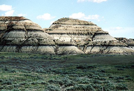
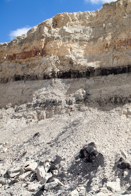
Strata of lignite in the Hell Creek beds, east of Fort Peck Dam in northeastern Montana.
Fort Union Formation
Near Snowden Bridge
© 2013 by Kristopher K. Townsend. Permission to use granted under the Creative Commons Attribution-Share Alike 4.0 International license.
After the captains turned west up the Missouri River from Fort Mandan on 7 April 1805, descriptions of coal beds and burnt appearances became common in their journals. On 9 April 1805, Lewis noticed “many horizontal statas of carbonated wood, having every appearance of pitcoal at a distance, were seen in the face of these bluffs. These stratas are of unequal thicknesses from 1 to 5 feet, and appear at different elevations above the water, some of them as much as eighty feet.” These descriptions reach their fullest in the area of the later fur-trading post of Fort Union, near the confluence of the Missouri and Yellowstone. It is here that the Tongue River Member of the Fort Union Formation “rises” above river level and displays its many beds of coal.
Lewis and Clark sometimes called this coal “carbonated wood” because sometimes they could see the outlines of woody stems and other plant remains. Coal geologists call it lignite, but Lewis and Clark were essentially correct in their description.
On 29 April 1805, when the Expedition was passing the heart of the Girard coalfield (in today’s Richland County, in northeastern Montana), Lewis gave one of the Expedition’s best descriptions of the coal in the formation and its relationship to clinker:
There is more appearance of coal today than we have yet seen. The stratas are 6 feet thick in some instances; the earth has been birnt in many places, and always appears in stratas on the same level with stratas of coal.
A few miles upstream from where Lewis wrote that, the Fort Union Formation lies farther from the river and was not observed by the Expedition. However, on the 17 May 1805, near present-day Seven-Blackfoot Creek, Clark saw some coal from the Fort Union Formation that had been “thrown out by the floods.”
Other coal and burnt appearances that the Expedition saw upriver from this point belonged to the Judith River and Eagle formations, which are even older than the Fort Union Formation.
Yellowstone Observations
On 28 July 1806, “glideing down this Smooth Stream,” the Yellowstone River, Clark’s party passed from the Cretaceous Hell Creek Formation into the Tullock Member of the Fort Union Formation.
In the evening I passd. Straters of Coal in the banks on either Side. Those on the Stard. bluffs was about 30 feet above the water and in 2 vanes [veins] from 4 to 8 feet thick, in a horozontal position. The Coal Contained in the Lard Bluffs is in Several vaines of different hights and thickness. This Coal or Carbonated wood is like that of the Missouri of an inferior quallity.
He was correct.
He recorded several observations of the Fort Union Formation among the red hills near Terry, Montana, on 31 July 1806. Five and one-half miles below the previous night’s camp at the mouth of the Powder River, he “passed under a high Bluff of different coloured earty on the Lard. side.” Four miles farther on he observed “high Coal bluffs on the Lard Side.” One and one-half miles farther he reached “a red bluff on the Lard. side.” Another eleven miles took him past “Steep Coal banks on each side” of “Coal River”—which Sheheke had called Oak Tar pon er, and we now call O’Fallon Creek.[1]The stream labeled Gibsons River on Atlas maps 121 and 123, Gibson River on Atlas map 125 and Gibsons Creek on Atlas map 126 actually is present-day Cabin Creek. “Coal River” in … Continue reading Eleven miles beyond that he saw “low coal bluffs on the Stard Side.” He had navigated through the Tullock, Lebo, Tongue River, and Ludlow members of the Fort Union Formation, where the coal beds have been burned, and have baked the adjacent mudstones into a most striking brick-red hue that slashes boldly across the faces of towering bluffs.[2]Of the captains’ many references to the sightings of coal along their route, this is the only reference that Nicholas Biddle included in his edition of the journals (1814).
Lewis, traveling back down the Missouri in late July and early August 1806, was making about 70 river miles per day and did not record much in the way of geology. Nevertheless, his journal makes it clear when he reached the area underlain by the Fort Union Formation.
On 7 August 1806 Lewis wrote that near the mouth of Martha’s River—today, Big Muddy Creek, which Clark named in honor of the “Selebrated” but anonymous “Miss M F”—”we meet with the first appearance of the coal, burnt hills and pumice stone. These appearances seem to be coextensive.” This area of lignite actually extends for about ten miles upriver from Big Muddy Creek, but the bedrock is deeply covered with glacial deposits, so little of it is exposed.
After leaving Fort Mandan en route home in the late summer of 1806, the Expedition was in too much of a hurry to note geographic and geologic features already described on the outbound trip. The Expedition exited the area underlain by the Fort Union Formation late in the day on 19 August 1806.
Strip-mining at Colstrip, Montana
In 1882 the Fort Union Formation’s coal resources were rediscovered, this time by competent geologists who soon realized that it is the largest lignite-bearing geological formation in North America. Mining began somethat tentatively only three years later, primarily for local heating purposes. Steam locomotives, originally designed to burn wood, were retrofitted in the mid-1890s to burn coal, and the deep mines near the town of Red Lodge, Montana filled the new need. Soon after the turn of the twentieth century, the same mines provided coal to fire generators that produced electricity. By 1924 steadily increasing rail traffic through the Northwest demanded more efficient coal extraction techniques, and strip-mining began at a place called Colstrip.
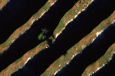
Eighteenth-century mining for pit-coal had left comparatively minor scars on the landscape. But strip-mining in the mid-twentieth century literally laid waste to thousands of acres of formerly productive land. The overburden—the soil and gravel built up over millions of years—was scraped off the coal veins, shoved aside, and left in long, steep, parallel ridges. The coal was removed, and the whole mess, pits and piles together, was eventually abandoned.
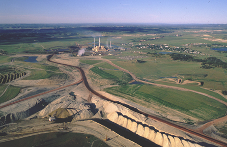
Because the process was purely extractive, without regard for the structure of the overburden, there is little or no hope of restoring it simply by leveling it off and planting grass and trees. Only in due time, thousands of years-worth of time, will natural processes prove able to restore the land to anything like its original condition. The photo above is an aerial view of some Colstrip leftovers from the thirties, seen also at extreme left in the photo below.
Since the mid-1970s, strip-miners in Montana, as well as in other states, are required by law to remove overburden in an orderly manner, to refill the pits after mining the coal, restoring the overburden as nearly as possible to its original condition, and to replant it with the original types of vegetation. “The art and science of mine reclamation are now so highly developed,” say geologists David Alt and Donald Hyndman, “that the recently worked sites are visible only to a knowing and practiced eye.”[3]David Alt and Donald Hyndman, Roadside Geology of Montana (Missoula, Montana: Mountain Press, 1986), p. 223. Proof of that may clearly be seen in the smooth prairies surrounding the pit in the above photo.
Some of the lignite mined here at Colstrip is used to generate electricity at the plant in the upper center. The rest is shipped to coal-fired generators in other parts of the country, via 100-car “unit” trains.
Notes
| ↑1 | The stream labeled Gibsons River on Atlas maps 121 and 123, Gibson River on Atlas map 125 and Gibsons Creek on Atlas map 126 actually is present-day Cabin Creek. “Coal River” in Clark’s journal narrative refers to present-day Cabin Creek, which joins the Yellowstone about ten miles downstream from Fallon Creek. See Gary E. Moulton, ed., Atlas of the Lewis & Clark Expedition (Lincoln: University of Nebraska Press, 1983). |
|---|---|
| ↑2 | Of the captains’ many references to the sightings of coal along their route, this is the only reference that Nicholas Biddle included in his edition of the journals (1814). |
| ↑3 | David Alt and Donald Hyndman, Roadside Geology of Montana (Missoula, Montana: Mountain Press, 1986), p. 223. |
Experience the Lewis and Clark Trail
The Lewis and Clark Trail Experience—our sister site at lewisandclark.travel—connects the world to people and places on the Lewis and Clark Trail.
Discover More
- The Lewis and Clark Expedition: Day by Day by Gary E. Moulton (University of Nebraska Press, 2018). The story in prose, 14 May 1804–23 September 1806.
- The Lewis and Clark Journals: An American Epic of Discovery (abridged) by Gary E. Moulton (University of Nebraska Press, 2003). Selected journal excerpts, 14 May 1804–23 September 1806.
- The Lewis and Clark Journals. by Gary E. Moulton (University of Nebraska Press, 1983–2001). The complete story in 13 volumes.


