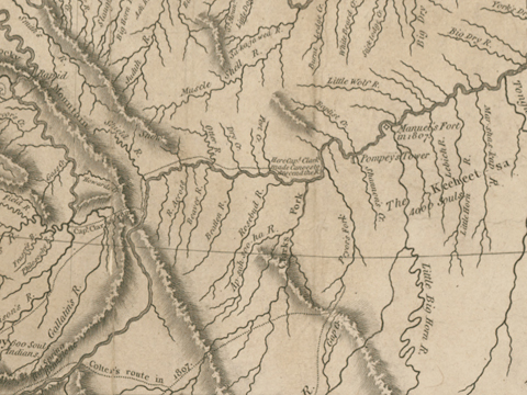
Clark’s mapping of the Yellowstone in 1806 resulted in his map of 1814. The latter map shows his conclusions regarding roughly 230 air miles along the Yellowstone to the Tongue River.
King’s 1803 Map
Lewis and Clark set out up the Missouri with a considerable amount of information they had gathered locally, plus a number of different maps, including one compiled in March 1803 by the Washington, D.C. cartographer and surveyor, Nicholas King, at the direction of Secretary of the Treasury Albert Gallatin. King’s instructions were to compile “a blank map” of North America from 88° to 126° west longitude and from 30° to 55° north latitude—roughly from the mouth of the Ohio to the Pacific Ocean, and from New Orleans to somewhat north of Lake Winnipeg. He was to combine the contents of earlier explorers’ maps, including those by Cook, Vancouver, Arrowsmith, David Thompson and Alexander Mackenzie.
King’s map represented all that was known or conjectured about the features of the whole area, and showed that the geography of the land between the Mandan and Hidatsa Indians’ homeland on the middle Missouri, and the lower Columbia River, was indeed a blank in the minds of Euro Americans.
Comparisons of King’s conjectural sketch with Clark’s chart from 1805 and the version of Clark’s concept which was published with Nicholas Biddle‘s 1814 paraphrase of the journals, show the magnitude of Clark’s contribution to the understanding of the geography of the Northwest. Never again would such a great cartographic leap be made by one man.
Jefferson’s Conjectures
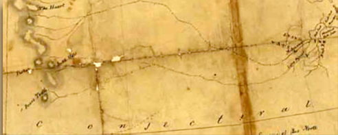
Thomas Jefferson and his circle of amateur geographers were under the impression that there were just two ranges of mountains in the West. The northern range, of which the southern end is shown here, were thought to end somewhere above the 45th parallel, and to be situated between 113° and 115° west longitude. The peaks named “The Heart,” “The Pap,” “Battle Hills” and “Bear’s Tooth” [Bears Tooth] were landmarks reported by Indians.
Conjecture also held that those “Stony Mountains” were separated from the mountains of “New Mexico” in the Southwest by a broad plateau. In fact, Jefferson specifically instructed Lewis to try to ascertain whether that plateau was mountainous or flat. Imagine Lewis’s feelings when he reached the mountain saddle today known as Lemhi Pass on the Continental Divide, knowing he was in the vicinity of the 45th parallel, to find still more mountains, as far as his eye could see. There was Jefferson’s answer!
At upper right is a cluster of details representing the villages of the Mandans and other Indian tribes in the vicinity of Knife River. Between them and the Stony Mountains are shown two branches of the Missouri River. The upper one is the proper Missouri; the lower corresponds to the Yellowstone River, which Clark would explore on the Expedition’s return in the summer of 1806.
By the time he reached Lemhi Pass Lewis on 12 August 1805, Lewis was certainly aware how far King’s map was off with regard to the sources of both branches of the Missouri. But when they descended into the valley to the west, he and Clark believed they had found the southern branch of the Columbia River that was represented on King’s map by the dotted lines extending to the center from the left edge of the map above. No wonder they insisted on exploring the Salmon River—their “Lewis’s River”—despite the Indians’ warnings that it was impassable.
Reality was coming into focus.
Indian Information
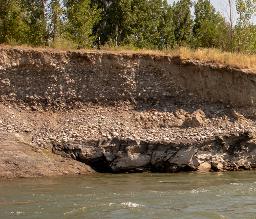
Yellowstone River near Laurel
© 24 July 2017 by Kristopher Townsend. Permission to use granted under the Creative Commons Attribution-Share Alike 4.0 International license.
The journal Clark wrote as he descended the Yellowstone contained as much confirmation as discovery, for he and Lewis had been attentive and adept students of their Hidatsa and Mandan mentors during the winter of 1804-05, and they had left Fort Mandan on 7 April 1805, with an extraordinary amount of new, mainly generalized, if here and there misunderstood, knowledge about the land they were to explore.
From the Hidatsas they learned that the Meé,-ah’-zah—literally, “stone river”—or Yellowstone river, joined the E-mâh-tark’-Ah’-zhah, or “river creek” Missouri about 3 miles above the mouth of the Ok-hah-,Âh-zhâh (literally “white creek”), or White Earth river. They heard that the Yellowstone was as large as the Missouri, and more rapid, that it originated in the Rocky Mountains, near the source of “a river on which the Spaniards reside,” though whether that was the Rio Grande or the Colorado was uncertain.
The Indians gave them a fairly clear picture of the three major reaches of the Yellowstone, with their distinctive characteristics. They learned that the river began in “broken ranges of the Rocky mountains. . . . stoney, and thickly timbered, the vallies said to be wide in many places and the lands fertile.” That was a reasonably accurate description of the stretch between Gardiner and Livingston that includes what is now known as Paradise Valley, which Clark did not explore.
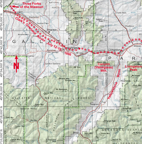
They were told that from the “big bend” at Livingston, where the river emerges between Wineglass Mountain and Livingston Peak, and the Oke-tar-pas-ah-ha—a Mandan name of unknown meaning; later O’Fallon’s Creek—the country was “more level, tho’ still broken, fertile and well timbered.” This was only partly true. As Clark was to find later, the soil was rocky and arid toward the lower end of this reach. He was back in the shortgrass prairie of the high plains.
Actually, the terraces of the valley floor are half gravel and stones, and half sand and silt. That’s why some of their horses’ hooves became so raw and bloody that the men had to fashion “Mockersons” of green (untanned) bison hide. As to timber, he saw only some scrubby pines on the mountainsides, and even in the river bottoms, he wrote, “I can See no timber Sufficient large for a Canoe which will Carry more than 3 men and such a one would be too Small to answer my purpose.”
Near today’s settlement of Park City, still within the reach he had understood the Indians to claim was “fertile and well timbered,” he observed, “the plains are butifull and leavel but the Soil is but thin, Stoney, and in maney parts of the plains & bottoms there are great quantity of prickly pears.” Indeed, the plains were so hard and dry that it was impossible to track the departing hoofprints when their horses were stolen.
Nonetheless, his optimism prevailed. When he reached the mouth of the Yellowstone on 3 August 1806, he insisted:
The Country through which it passes from those Mounts. to its junction is Generaly fertile rich open plains, the upper portion of which is roleing, and the high hills and hill sides are partially covered with pine and Stoney. The middle portion or from the enterance of Clarks Fork as low as the buffalow shoals, the high lands Contain some Scattering pine on the Larboard Side. On the Starboard, or S. E. Side is Some hills thickly Supplied with pine.
A Navigable River?
The Indians told them there were “no stream[s] worthy of notice which discharge themselves into this river on the N. side, the country between this river, and the Missouri being watered by the Mussle shell river.” That was true as far as it went, but the Indians evidently forgot, or the captains lost in the translation, the river they would name after their prized blacksmith, gunsmith, and carpenter, Private John Shields, then 40 years old, and their senior enlisted man. The sources of the Shields River are shared by the Bridger Range and the Crazy Mountains (see Rocky Mountains).
The captains wrote down the Indian names for at least a dozen tributaries of the Yellowstone, and Clark found most of them—the Powder, the Tongue, the Bighorn, Oke-tar-pas-ah-ha (later to become O’Fallon Creek, after William Clark‘s nephew, Benjamin O’Fallon), and (the Indians translated the name) Stinking Cabin Creek.
The best news at the time was that the Yellowstone was navigable as far as the Big Bend at Livingston. That would have been almost 500 miles above its confluence with the Missouri, and would have brought river commerce to within easy reach of the east fork of the Gallatin River, which also, by Indian standards, was “navigable” by small craft. Clark would estimate that portage to be only 18 miles long, “on an excellent high dry firm road with very inconsiderable hills, plus another 18 miles to the nearest part of the main fork of Gallitine . . . through a leavel plain.”
His view of the Yellowstone as a navigable river grew more perfect in his mind as he descended it, and upon arrival back at the Missouri on August 3 he concluded: “The Rochejhone or Yellow Stone river is large and navagable with but fiew obstructions quite into the rocky mountains”—adding, despite Indian information to the contrary, plus the fact he had seen no evidence of this—”and probably near it’s source.”
This vision of the Yellowstone as a riverine superhighway would survive year by year until after mid-century. The commercial enterprises that were headed for the Yellowstone even as Clark was descending it, were traveling by the old reliable means—keelboats, bateaux, pirogues and canoes.
Clark’s Methodology
President Jefferson’s orders to Lewis were expressly to take careful observations of latitude and longitude, especially at the mouths of rivers. Those readings were to serve as checks on the daily compass courses and estimated distances between landmarks.[1]Donald Jackson, ed., Letters of the Lewis and Clark Expedition with Related Documents, 1783–1854 (Urbana: University of Illinois Press, 1978), 62. Nonetheless, Clark continued to record courses and distances, although the latter were much less accurate than his measurements on the Missouri. For example, he estimated the length of the Yellowstone from the Big Bend where he reached it, to its confluence with the Missouri, at 837 miles (1347 km). Today the same stretch measures 498.2 miles (802 km), and its channel has not changed appreciably during the past 200 years.[2]River Mile Index of the Yellowstone River, Water Resources Division, Montana Department of Natural Resources and Conservation (September 1976), 53. But Clark did not make any celestial observations on his entire journey down the Yellowstone, and even if he had, he would not have had the knowledge of trigonometry to complete the calculations. So he could only guess at the distance Pryor would need to cover.
In 21st-century terms, the confluence of the Bighorn River with the Yellowstone is located at approximately 46 degrees, 10 minutes north latitude and 107° 28′ west longitude; the mouth of the Knife River on the Missouri is at about 47° 20′ north latitude and 101° 23′ west longitude. In other words, the mouth of the Bighorn is 46° 10′ north of the Equator, and 107° 28′ west of the prime meridian, which runs through Greenwich (pron. GREN-itch), England. And so on. (The lines marking degrees of latitude on a map are called parallels; lines indicating longitude are called meridians.)
A degree of latitude at about halfway between the equator and the North Pole is equal to approximately 69 miles (111 km); a minute is 1/60th of that, or 1.15 miles (1.85 km). A degree of longitude at the same parallel equals 48.35 miles (78 km), and a minute, 0.8 mile (1.3 km). We know, therefore, that the extremities of Sheheke‘s route lie on meridians that are 249.1 miles (401.7 km) apart, and on parallels that are 80.5 miles (129.8 km) apart. Therefore, if Sheheke’s route really was a more or less straight line, it would have been 329.5 miles (531.5 km) long.
One might say it was a mixed review.
Clark’s 1814 Map
The detail from Clark’s map of 1814 shows his post-expeditionary conclusions regarding the lay of the land from just west of the Three Forks of the Missouri, roughly 230 air miles eastward along the Yellowstone to the Tongue River. It shows how much Clark learned from the Indians, and how much he learned on the ground himself. It also reflects a little of the information he got from former expedition members like John Colter, as well as other travelers to this part of the West between 1806 and 1813.
Bear in mind that Clark knew the approximate latitude of the Three Forks, as well as the confluence of the Yellowstone with the Missouri, but he didn’t take any astronomical readings during his trip between those points, and he had nothing more than a feel for the longitude of either. He kept daily records of compass bearings and estimated distances between landmarks along the way, but his distances were overall so far off that he concluded the length of the Yellowstone from the Big Bend to the Missouri was 837 miles, when it was probably about what it is today, 438 miles.
For all its “mistakes,” by 21st-century standards, it also shows Clark’s extraordinary ability to observe and remember details, and to extrapolate from them generalizations about the terrain he covered. In other words, Clark had a capacity for geographic memory and imagination that enabled him to feel the earth beneath and around him. In comparison with the map he drew in 1810 (not shown here), which was a preliminary compilation of his field sketches, the 1814 map also shows how his grasp of Northwestern geography matured over time. With it, he gave a palpable shape to the land he had traveled, which other travelers and explorers were to rely upon for the next fifty years.
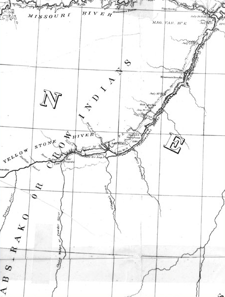
Warren’s 1856 Map
In 1856, having accompanied the General W. S. Harney’s Sioux Expedition up the Missouri River, 27-year-old Lt. Gouverneur Kemble Warren,[3]He was not a lieutenant governor. He was a lieutenant whose given name was Gouverneur. of the Army’s elite Department of Topographical Engineers, was ordered to map the Missouri through Dakota Territory—from the mouth of the Kansas to the mouth of the Milk, and the Yellowstone as far as the Tongue. At Fort Union, on the Missouri opposite the mouth of the Yellowstone, Warren hired the famous mountain man and trader, Jim Bridger (1804–1881), as a guide. He purchased wagons and mules from the notorious British “sportsman” Sir St. George Gore,[4]See Dave Walter, “The Unsaintly Sir St. George Gore, Slop Hunter Extraordinaire,” in Dave Walter, ed., Speaking Ill of the Dead: Jerks in Montana History (Guilford, Connecticut: Globe … Continue reading who happened to be at Fort Union, then proceeded by steamboat 100 miles up the Yellowstone, the wagons following the river on the north bank, to a point about ten miles above Glendive’s Creek, where the steamboat left supplies and returned to the Missouri River, while Warren and his crew rode mules to the mouth of the Powder River. They floated back down the Yellowstone to Fort Union in bull boats.
Most of the tributaries have already lost the names Clark gave them, and some new ones have been added. Glendive’s Creek, which Clark did not record, is thought to be a corruption of the name Glendale, given it by Gore, who camped in that vicinity the year before Warren got there. O’Fallon’s Creek, previously Oak-tar-pon-er, Oahtaroup, or Coal, Creek (31 July 1805), was renamed by an unknown person for the trader, Indian agent, and nephew of William Clark, Benjamin O’Fallon (1793–1842). “Braseau’s Houses” was a trading post established by John Brazeau, a clerk with the American Fur Company, in 1833.
Two important elements have been added. One is the location of each of the major rapids mentioned by Clark in the 1814 edition of the journals, but not shown on his 1814 map. The other is a sequence of topographic elevations—which Clark could not have reckoned at all—that are reasonably close to those determined by 20th-century means. At the mouth of the Powder River, for instance, Warren’s elevation of 2360 feet above mean sea level is 2234 ft MSL on modern maps.
The Steamboat Era
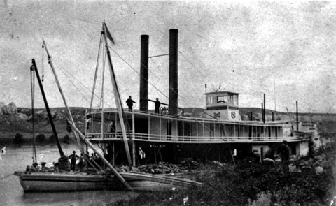
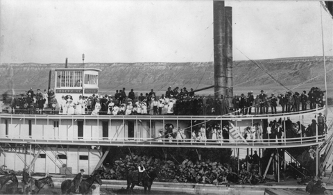
The sternwheel steamboat Josephine
on the upper Missouri River in the 1880s.
Montana Historical Society, Helena.
The Josephine was built in 1873 at Freedom, Pennsylvania, a few miles down the Ohio River from Pittsburgh, to the specifications of the experienced Missouri River captain, Grant Marsh. She measured 178 feet from stem to stern, with a beam of 31 feet and a six-foot hold. Powered by two engines and two boilers, she had a capacity of 300 tons, though she drew only about a foot of water. The spars at the bow were used in winching her over shoals when the water was low. Another technique was “grasshoppering,” in which long sturdy poles were driven into the river bottom, and ropes with block and tackle were used to raise and drag the boat forward, foot by foot.
She spent her senior years on the lower Missouri, clearing snags for the Corps of Engineers. She sank after striking an ice floe in 1907; her boilers and machinery were salvaged and shipped to the Yukon River.[5]John G. MacDonald, “History of Navigation on the Yellowstone River” (master’s thesis, Montana State University, 1950).
Notice the firewood stacked on the main deck. By the end of the steamboat era professional woodcutters—”woodhawks”—had practically stripped the banks of the Missouri and its navigable tributaries of all cottonwood trees. The coal that Clark had seen in the banks of the Yellowstone River wouldn’t burn hot enough for steamboat boilers.
But the definition of “navigability” was to grow steadily narrower. Even as Meriwether Lewis made his way down the Ohio River in 1803, the Irish-American Robert Fulton (1765–1815) was demonstrating his experimental steamboat in Paris, and by the time Lewis was back east in 1807, Fulton and his partner, Robert Livingston, were about ready to begin commercial steamboat service on the Hudson River. Four years later, Fulton made a bold attempt to conquer the Ohio and the Mississippi Rivers by the same means. It was not a successful attempt, for several reasons, but a beginning, at least.[6]See John Seelye, Beautiful Machine: Rivers and the Republican Plan, 1755–1825 (New York: Oxford University Press, 1991), 227–47.
In 1819, the U.S. Army mounted the first “Yellowstone Expedition” with a small fleet of steamboats. Partly exploratory, partly a show of military force to intimidate the Indians, it was technologically premature, and it didn’t even reach the mouth of the Yellowstone—”a fiasco,” historian Hiram Chittenden called it.[7]William H. Goetzmann, Army Exploration in the American West, 1803–1863 (Austin: Texas State Historical Association, 1991), 39–45. Hiram Chittenden, The American fur trade of the far … Continue reading It was another decade before John Jacob Astor’s American Fur Company would begin using steamboats on the Missouri.
Not until the 1860s, driven by regional military needs, did the new technology meet the Yellowstone River’s demands, but then only irregularly, for the lack of sufficient firewood and the hazards of Wolf Rapids, Bear Rapids and Buffalo Shoals were major handicaps.[8]That low-grade coal Clark had noticed in the banks in 1806 would not burn satisfactorily in boilers designed for wood fuel. In 1873, there were still doubts about the river’s navigability. In May of that year, under the skillful command of Captain Grant Marsh, and with the famous “Yellowstone” Kelly aboard as chief scout and hunter, the Key West made it to within two miles of the Powder River.[9]John G. MacDonald, “History of Navigation on the Yellowstone River,” master’s thesis, Montana State University, 1950.
The longest-lived steamboat to ply the Yellowstone was the Josephine, which made its first trip in June 1873, and in 1875 ascended as far as today’s Billings, Montana. The primary purpose of the voyage was to survey the river’s navigability for steamboats that might supply military outposts farther up the Yellowstone. A secondary task was to transport and supply troops en route to protect from Sioux warriors the engineers and surveyors who were preparing the way for the Northern Pacific Railroad—a paradigm shift that would make the likes of her obsolete in less than a decade.
Conclusion
[Fort Clatsop, 14 February 1806]
I completed a map of the Countrey through which we have been passing from the Mississippi at the mouth of the Missouri to this place. In the Map the Missouri, Jefferson’s river, the S.E. branch of the Columbia or Lewis’s river, Koos-koos-ke and Columbia, from the enterance of the S. E. fork to the pacific Ocian, as well as a part of Clark’s river and our track across the Rocky Mountains, are laid down by celestial observations and Survey. . . . We now discover that we have found the most practicable and navigable passage across the Continent of North America.
[—William Clark]
William Clark, the expedition’s cartographer, drew sketch maps en route, and assembled them into three comprehensive maps of the Western United States and lower Canada, reflecting successive changes in the way the West was envisioned. The first was drawn at Fort Mandan in 1804-05, the second at Fort Clatsop in 1805-06, and the third—following the expedition—in St. Louis in 1809-10.
His third map, revised and published in 1814, showed that the western half of the continent was not a mirror of the East, and that the Rocky Mountains did not resemble the Appalachians or other eastern ranges, as had been supposed, but consisted of a large number of interlocking ranges nearly 250 miles wide in the area where Lewis and Clark crossed them. It defined the shape and scope of the Missouri and Columbia River drainages. Above all, it permanently disposed of the durable old legend of a continuous, or at least near-continuous, navigable water route across North America.
Clark’s final map served as a basic reference and guide to westward-bound Americans for another three decades, all the while being steadily revised and expanded by fur traders, missionaries, emigrants, and entrepreneurs on the Santa Fe Trail (1821), the Mormon Trail (1840) and the Oregon Trail (1843). Further government surveys between 1850 and 1890, plotting routes for wagon roads and railroads, added still more dimensions to Americans’ understanding of their nation’s geography.
The construction of modern highways began under the impetus of bicyclists in the East in the 1880s and 90s, and the movement toward a national highway system continued with the Good Roads Movement around the turn of the twentieth century. Spurred by the rapid growth of the automobile industry after 1900, the Federal Aid Highway Act of 1921 established state highway systems, and led to the designation of cross-country federal highways such as U.S. 2, 10, 12, 14, and 30, portions of which more or less closely parallel the route of the Lewis and Clark expedition. The Interstate Highway System, begun in the 1950s, once more changed travelers’ perspectives on the West.
In the mid-twentieth century, the waterways that Lewis and Clark followed from home to the Pacific Ocean and back—the Ohio, Missouri, Jefferson, Beaverhead, Clearwater, Snake, and Columbia Rivers—were largely rebuilt, mile by mile, into a series of commercial waterways and reservoirs for irrigation and flood control.
For Further Reading
Encyclopaedia Britannica CD 97, “Roads and Highways.”
John Logan Allen, Lewis and Clark and the Image of the American Northwest. New York: Dover, 1975.
Notes
| ↑1 | Donald Jackson, ed., Letters of the Lewis and Clark Expedition with Related Documents, 1783–1854 (Urbana: University of Illinois Press, 1978), 62. |
|---|---|
| ↑2 | River Mile Index of the Yellowstone River, Water Resources Division, Montana Department of Natural Resources and Conservation (September 1976), 53. |
| ↑3 | He was not a lieutenant governor. He was a lieutenant whose given name was Gouverneur. |
| ↑4 | See Dave Walter, “The Unsaintly Sir St. George Gore, Slop Hunter Extraordinaire,” in Dave Walter, ed., Speaking Ill of the Dead: Jerks in Montana History (Guilford, Connecticut: Globe Pequot Press, 2000), pp. 7–23, Roberta Carkeek Cheney, Names on the Face of Montana: The Story of Montana’s Place Names (rev. ed., Missoula, Montana: Mountain Press, 1984), p. 120. Gore didn’t quite single-handedly eliminate the vast numbers of bison, bear, antelope and other wildlife that had so impressed Lewis and Clark, but he definitely put a dent in it. And the memory lingers on in the misspelled name of a creek and a town. |
| ↑5 | John G. MacDonald, “History of Navigation on the Yellowstone River” (master’s thesis, Montana State University, 1950). |
| ↑6 | See John Seelye, Beautiful Machine: Rivers and the Republican Plan, 1755–1825 (New York: Oxford University Press, 1991), 227–47. |
| ↑7 | William H. Goetzmann, Army Exploration in the American West, 1803–1863 (Austin: Texas State Historical Association, 1991), 39–45. Hiram Chittenden, The American fur trade of the far West (2 vols., New York: Barnes & Noble, 1935), II:580–87. |
| ↑8 | That low-grade coal Clark had noticed in the banks in 1806 would not burn satisfactorily in boilers designed for wood fuel. |
| ↑9 | John G. MacDonald, “History of Navigation on the Yellowstone River,” master’s thesis, Montana State University, 1950. |
Experience the Lewis and Clark Trail
The Lewis and Clark Trail Experience—our sister site at lewisandclark.travel—connects the world to people and places on the Lewis and Clark Trail.
Discover More
- The Lewis and Clark Expedition: Day by Day by Gary E. Moulton (University of Nebraska Press, 2018). The story in prose, 14 May 1804–23 September 1806.
- The Lewis and Clark Journals: An American Epic of Discovery (abridged) by Gary E. Moulton (University of Nebraska Press, 2003). Selected journal excerpts, 14 May 1804–23 September 1806.
- The Lewis and Clark Journals. by Gary E. Moulton (University of Nebraska Press, 1983–2001). The complete story in 13 volumes.
