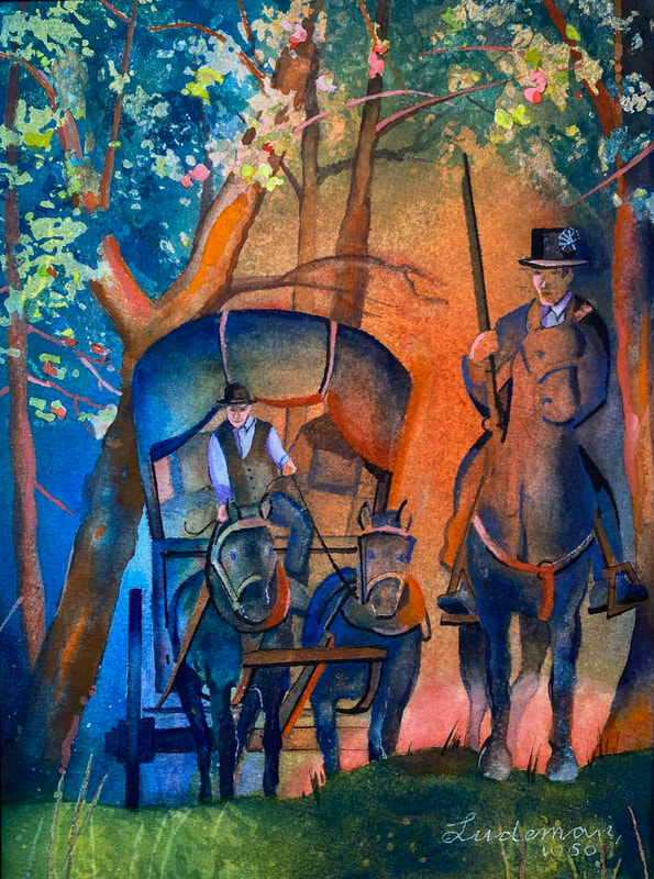
On his way to Pittsburgh, Lewis travels between Grantsville, Maryland and Farmington, Pennsylvania—likely on this day. After crossing the Youghiogheny River, Lewis would have another chain of Allegheny mountains to pass. His wagon carrying the weaponry and equipment from Harpers Ferry travels the road separately.
On Braddock’s Trace
Watercolor by Steve Ludeman
© 2023 by Steve Ludeman, www.steveludemanfineart.com. Used by permission.
This painting shows the freight wagon with Army escort in the early morning on Braddock’s Trace.—Steve Ludeman
Allegheny Crossings
[October] 26th.
It can then be readily conceived that clouds passing over the mountains would, from the interference of these mountainous heights, cause the contents of the clouds to be prematurely showered down. Notwithstanding the rain, Genl. Orders were issued for the troops to march, & at 10 o’clock the tents were struck, & the Infantry & artillery proceeded to Simkins’s, & the Cavalry as far as Mountains & Augustines.
. . . . .
This part of the world, & its inhabitants appeared to me to be in strict alliance with every thing that can be called filthy & undesirable.
27th, Monday.
Remained in this most uncomfortable situation the greater part of the day, a portion of which was by all the officers in the neighborhood devoted to visiting each other, without discovering anything that could lead to a wish for an exchange of Quarters.
. . . . .
This evening it again rained, which, if possible, increased our dissatisfaction.
Tuesday, the 28th of October. Left this detestable part of America, & proceeded to the great crossings of the Youghogany (three miles), which, from the rapidity & depth of the water, was with some difficulty, &, in several instances, with some danger forded by the Cavalry.
Octr 31st.
The weather very bad. Nov’r 1st, 2nd, 3rd & 4th almost a constant rain the streets unaccountably mirey, which hourly exposed my health to all the bad consequences of feet constantly damp, & my situation requiring some share of activity, I was almost hourly exposed to every influential effect of Rain upon the human frame.
—Robert Wellford[1]Robert Wellford, “A Diary Kept by Dr. Robert Wellford, of Fredericksburg, Virginia, during the March of the Virginia Troops to Fort Pitt (Pittsburg) to Suppress the Whiskey Insurrection in … Continue reading
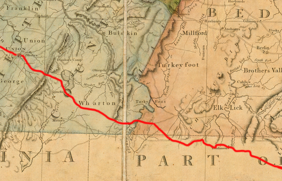
A Map of the State of Pennsylvania (Detail)
by Reading Howell, 1792
94 cm by 162 cm, David Rumsey Collection.
In the above map by Reading Howell, the route likely taken by Meriwether Lewis in 1803 on his way from Harpers Ferry to Pittsburgh has been highlighted in red by this editor. The map also shows alternate routes available to the troops moving towards Pittsburgh to stop the Whiskey Rebellion. The American regiments were travelling on different routes and schedules to prevent over-taxing the resources available at the time. After leaving Tomlinsons (lower-right), Dr. Wellford crossed the Little Youghiogheny and then went north to “Jones’s” (upper center) just east of the Laurel Hill crossing. He then made his way to Uniontown [Union on the map]. No matter which route Lewis followed in 1794, it is likely the rains forced him to scramble for any shelter better than a tent. In July 1803, he likely felt grateful for the comparatively abundant options for food and lodging.
Experience the Lewis and Clark Trail
The Lewis and Clark Trail Experience—our sister site at lewisandclark.travel—connects the world to people and places on the Lewis and Clark Trail.
Plan a trip related to July 12, 1803:
- Harpers Ferry to Brownsville (Inspiration Trip)

Notes
| ↑1 | Robert Wellford, “A Diary Kept by Dr. Robert Wellford, of Fredericksburg, Virginia, during the March of the Virginia Troops to Fort Pitt (Pittsburg) to Suppress the Whiskey Insurrection in 1794.” The William and Mary Quarterly 11, no. 1 (1902): p. 7, accessed 24 November 2022 from doi.org/10.2307/1915481. |
|---|


